Good morning. This is Dave Zinn with the Gallatin National Forest Avalanche Forecast on Monday, January 16th at 7:15 a.m. This information is sponsored by Highline Partners and Cooke City Super 8/Bearclaw Bob’s. This forecast does not apply to operating ski areas.
In the last 24 hours, the mountains near West Yellowstone received 5” of new snow, with 1-3” across the rest of the forecast area. Temperatures are in the upper teens to low 20s F and winds are 5-10 mph from the west to north. Today, temperatures will be in the 20s F with 5-10 mph winds from the west to south. An inch of snow will fall this morning before the clouds begin to break.

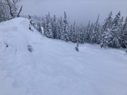
Dangerous avalanche conditions exist in the mountains around West Yellowstone, where 5” of new snow is adding weight to a weak layer of fragile surface hoar now buried 12-18” deep. Do not trust this layer of feathery dominos. Its spotty distribution makes snowpack assessment challenging because your snowpit may not represent nearby slopes. This layer exists on many slopes and is resulting in human-triggered slides (Lionhead video). Yesterday, skiers triggered two avalanches near Hebgen Lake, one breaking 100’ wide and a foot deep (photo and details, observation).
Weak layers buried deeper in the snowpack can result in larger avalanches. Careful route-finding and conservative decision-making are essential. Avoiding slopes steeper than 30 degrees is advisable.
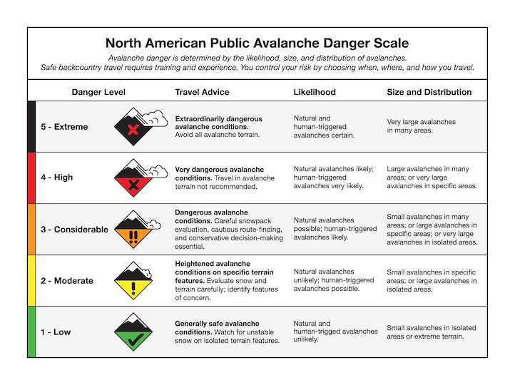
Human-triggered avalanches are likely, and the danger is rated CONSIDERABLE.

Human-triggered avalanches failing within the new and wind-drifted snow, a foot deep on a layer of buried surface hoar, or on weak layers deeper in the snowpack are possible in the Madison Range, Southern Gallatin Range, and in the mountains near Cooke City. Two to 3” inches of new snow in the last 24 hours are incrementally loading the snowpack. The layer of feathery surface hoar buried a foot deep on many slopes is our primary concern (Buck ridge, Lionhead, Taylor Fork, Cooke City). Dig, test, and build in an extra margin for error due to the spotty nature of this weak layer. It has resulted in avalanches in the Lionhead area and will eventually do the same where the snowpack structure is similar.
Evaluate the snowpack carefully for instability related to buried weak layers and make conservative terrain decisions with many potential avalanche problems. The danger is rated MODERATE.

Without significant loading from new or wind-drifted snow, triggering a large avalanche in the Bridger and Northern Gallatin Ranges is unlikely. This is not a pass to turn off our brains, a group of skiers near Frazier Basin turned around before their second steep line of the day after their snowpack assessment revealed potential instability (observation). From Mount Blackmore, Alex recommended remaining diligent about snowpack assessment and following safe travel protocols even as the likelihood of avalanches decreases (video). Today, small avalanches breaking within the new and wind-drifted snow are concerning in terrain where they could carry you into or off terrain traps like trees, rocks and cliffs.
The avalanche danger is LOW.
Please share avalanche, snowpack or weather observations via our website, email (mtavalanche@gmail.com), phone (406-587-6984), or Instagram (#gnfacobs).

Dangerous avalanche conditions exist in the Centennial Mountains in Island Park, where 5” of new snow is adding weight to a weak layer of fragile surface hoar now buried 12-18” deep. Do not trust this layer of feathery dominos. Its spotty distribution makes snowpack assessment challenging because your snowpit may not represent nearby slopes. Weak layers buried deeper in the snowpack can result in larger avalanches. Careful route-finding and conservative decision-making are essential. Avoiding slopes steeper than 30 degrees is advisable today.
Upcoming Avalanche Education and Events
Our education calendar is full of awareness lectures and field courses. Check it out: Events and Education Calendar.
TOMORROW, Tuesday, January 17th, 6 p.m., Silent auction and ski movies to support the Darren Johnson Memorial Avalanche Education Memorial Fund @ The Independent in Big Sky, $10
Thursday, January 19th, 4-8 p.m., Pint Night to support the Darren Johnson Memorial Avalanche Education Memorial Fund @ Beehive Basin Brewery
Every Saturday, 10 a.m. - 2:00 p.m. Avalanche Rescue Training, drop in for any amount of time. Round Lake Warming Hut, Cooke City. Free.
Loss in the Outdoors, is a support group for those who have been affected by grief and loss related to outdoor pursuits. Check out the link for more information.
KING AND QUEEN OF THE RIDGE, FEBRUARY 4TH
Do you like to hike? Do you like to ski? Then the King & Queen of the Ridge is for you. Hike, ski and raise money for the Friends of the Avalanche Center in their 2nd biggest fundraiser of the year. Join the effort to promote and support avalanche safety and awareness! Fundraising prizes for the top 5 individuals who raise over $500. No racing is necessary to compete for the fundraising prizes. Info is HERE. Race participants for the February 4th event must register separately with Bridger Bowl HERE.
There are two events happening next week to help spread awareness about the Darren Johnson Avalanche Education Fund and generate donations for the next recipients to attend National Avalanche School in October 2024: a movie night at the Independent Theatre on Tuesday, January 17 and a raffle and pint night at Beehive Basin Brewery on Thursday, January 19 (poster).