All Avalanche Incidents for Advisory Year 2018-19
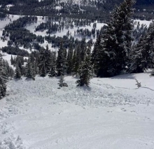
SS-ASc-R2-D2-I
Elevation: 10,000
Aspect: N
Coordinates: 45.4451, -111.0040
Caught: 0 ; Buried: 0
From e-mail: "A ski cut at the top of the slope produced a soft slab avalanche (R2 D2 SS). The crown was 10" deep and 60' wide. Several other skiers had skied a line to the skiers right of our route with no obvious signs of instability or avalanches. No natural avalanches were observed with the exception of some small wet point release slides on the E face of Mt Blackmore."
More Avalanche Details


WS-N-R3-D3-O
Elevation: 10,000
Coordinates: 45.2991, -111.5220
Caught: 0 ; Buried: 0
Natural wet slabs were widespread on Fan Mtn. near Big Sky during the week of 5/13-5/16.
More Avalanche Details


WS-N-R4-D2.5-O
Elevation: 9,600
Aspect: S
Coordinates: 45.3508, -111.4040
Caught: 0 ; Buried: 0
Skiers saw a large wet slab that released naturally sometime before 0745 on Tuesday (5/14).
More Avalanche Details


WS-NC-R2-D2.5-O
Elevation: 9,000
Aspect: E
Coordinates: 45.7952, -110.9350
Caught: 0 ; Buried: 0
Wet slab released naturally Tuesday (5/14/19) evening on Saddle Peak. "South side of 1/4 Saddle slid sometime last night. Looks like cornice drop then step down to near ground. Hi yesterday at Alpine was 62." -R. Elliott/BBSP
More Avalanche Details


WS-N-R3-D2.5-G
Elevation: 7,750
Aspect: E
Coordinates: 45.8240, -110.9250
Caught: 0 ; Buried: 0
"South side of the Glide Plane released as a glide avalanche last evening (May 12th) sometime around 6 pm according to source. Bed surface was ground in starting zone of wet clay soil sparsely covered in long grass. Debris chunks, some snowmobile sized, rode up on surface and slid approx. 200 vert. Debris could have bumped a tower on the old Alpine lift if it still lived there. Last freeze was 6 am on the 10th of May. The high temperature on the 12th was 59 degrees at 4 pm."
From BBSP Avalanche Atlas:
Interesting Events:
"The Glide Plane annually develops a significant glide crack starting on the north side of the lower section. There is only one event (late 1960’s) of this path breaking out to the ground that can be recalled (glide avalanche). This occurred sometime when Randy Elliott was a grade-schooler and it did damage to a tower on the old Alpine lift. A deflector was then built onto the damaged tower. Mitigation efforts throughout the 80’s consisted of extensive boot packing early season and one attempt of encircling entire slope with det chord. These efforts proved futile, as the crack still developed and the slope remained intact.
Circa 2013 when the original Alpine chair was removed, the road cut known as the 3 Bears Traverse was filled back in with its original material that had been the foundation of the unload station of the old Alpine. This is the 3rd season (2016) with the original landscape, the glide crack has still opened but the slope has stayed in place.
Early 1980’s, Joel Jurgens wanted to test the slope because of rapid movement. Buried big shots on flanks and Goldilocks Traverse level strung together with det cord. –Randy Elliott 2017" - Pete Maleski 2015-2016
More Avalanche Details


Elevation: 10,000
Aspect: N
Coordinates: 45.3581, -111.3760
Caught: 0 ; Buried: 0
From e-mail: “We found soft snow and great skiing in the morning, with a few wind affected pockets (my partner triggered a wide but thin wind slab coming into the hellroaring basin). By noonish the winds picked up quite a bit, quickly creating thin and sensitive wind slabs as we made our way down the SE face. The small slides we created could have been dangerous in exposed terrain.”
More Avalanche Details

L-AS-R2-D1.5-I
Elevation: 8,400
Aspect: E
Coordinates: 45.8158, -110.9290
Caught: 0 ; Buried: 0
Skiers easily triggered loose snow avalanches of the 3-5” of new snow. This morning (4/27) on the Bridger Ridge. Photo: @smooneyski
More Avalanche Details

WS-AM-R2-D2-O
Elevation: 9,500
Aspect: NE
Coordinates: 45.0584, -109.9630
Caught: 0 ; Buried: 0
Several similar slides WS-R2-D1.5/2 were observed on 4/20/19. Many probably triggered by snowmobilers. At lower elevations natural slides were breaking to the ground. Several larger crowns were observed near Goose Lake on 4/23/19.
More Avalanche Details


WS-N-R3-D2.5-I
Elevation: 10,000
Aspect: NE
Coordinates: 45.2648, -110.7010
Caught: 0 ; Buried: 0
From e-mail: "recent wet slab by Emigrant peak as well as a large wet loose (very similar avy activity noted across the valley, and i would guess similar activity in some of the fx zones). Wet slab 3-5’ crown estimation, all look connected/pulled out upon one another,..."
More Avalanche Details


WS-N-R3-D2.5-G
Elevation: 9,000
Aspect: N
Coordinates: 44.9978, -109.9780
Caught: 0 ; Buried: 0; Killed: 0
This natural wet slab avalanche on Wall Mountain outside of Cooke City failed near the ground. It was big- estimated crow size was 3-6' deep and 400' wide. Photo: B. Fredlund
More Avalanche Details

WL-N-R2-D1.5-S
Elevation: 8,000
Coordinates: 45.9072, -110.9750
Caught: 0 ; Buried: 0
Today (4/19/19) there were more and larger wet slides in addition to those that slid yesterday. Activity started before noon and slides were D1.5-D2 wet loose. One wet slab released north of Bridger Peak around 1400, probably from a cornice fall. There was widespread activity in addition to yesterday's slides on all slopes from Bridger Peak through Frazier Basin.
More Avalanche Details


WS-N-R3-D2-I
Elevation: 8,500
Aspect: E
Coordinates: 45.7743, -110.9380
Caught: 0 ; Buried: 0
One wet slab released north of Bridger Peak around 1400, probably from a cornice fall. Today (4/19/19) there were more and larger wet slides on top of and adjacent to those that slid yesterday. Activity started before noon and slides were D1.5-D2 wet loose. There was widespread activity in addition to yesterday's slides on all slopes from Bridger Peak through Frazier Basin.
More Avalanche Details
WL-N-R2-D3-O
Elevation: 10,500
Aspect: E
Coordinates: 45.2957, -111.5130
Caught: 0 ; Buried: 0
From BSSP: "There was considerable cornice growth... in most cases, natural failure sometime early morning, triggering recent wind slabs. Shots were producing very local results, with the exception of orbit in the gum wall, failing size 2 on storm/old snow interface. Also, low on the west wall, an east aspect, we had a 2’ crown triggered by cornice failure. This failed on a maybe week-old interface and partly filled the terrain trap. Similar stubborn results were observed on route, but once warmed up, these slabs became active in lenin, dirtbag wall, and hanging valley triggered on skis this afternoon. The upper a-z’s, pinnacles, and dirt bag wall were problematic with natural wet loose failure in most areas by late afternoon, running on previous melt/freeze crust.
In the backcountry, fan mtn and cedar mtn failed well into older layers on east aspects from cornice failure, up to size 3-sizeable avalanches."
More Avalanche Details
WL-N-R2-D1.5-S
Elevation: 8,000
Coordinates: 45.8068, -110.9230
Caught: 0 ; Buried: 0
Observed widespread natural wet loose slides, D1-D2, from Bridger Peak to north of Frazier Basin. Biggest on E-SE aspects in large terrain in northern Bridgers. Wet snow on NE up to 8,000 feet. Saw one maybe recent (poor viz) D2 slab in bowl south of Naya Nuki and some fresh small cornice fall/slabs at ridgeline. Widespread, but nothing major destructive.
More Avalanche Details


SS-N-R1-D1.5-I
Elevation: 9,600
Aspect: E
Coordinates: 45.0047, -109.9560
Caught: 0 ; Buried: 0; Killed: 0
Natural slab avalanche at the bottom of the Fin on Mt. Republic. Photo: B. Fredlund
More Avalanche Details

SS-N-R2-D2-I
Caught: 0 ; Buried: 0
Skiers observed natural and human-triggered avalanches on Abiathar, Yellow Mountain, Bridger Bowl, and in the Crazy Mountains. The avalanche in the Crazies partially buried a solo skier, who was luckily uninjured and able to dig himself out. These avalanches failed at the interface between old and new snow, most of which were on wind-loaded slopes. Photos: D. Proudfoot, G. Antonioli
More Avalanche Details


SS-ASu-R2-D2-S
Elevation: 10,000
Aspect: N
Coordinates: 46.0213, -110.2840
Caught: 1 ; Buried: 1
From e-mail: "[A solo skier] was turning around [on the face of Crazy Peak] after noticing the wind was affecting the snow when he got hit from above and partially buried, losing some belongings. He was able to dig himself out and was uninjured... He said he thought the slide broke 200 feet wide, and ran from the middle of the face to the bowl."
More Avalanche Details
SS-ASu-R1-D1
Caught: 0 ; Buried: 0
A group of skiers reported triggering a small wind slab avalanche in the Northern Bridger Range. No one was caught. A separate group also wrote: "On east facing test slopes near 8,000 feet we found very reactive wind slabs, about 8-12 inches deep." And they saw recent natural activity.
More Avalanche Details

SS-ASc-R1-D1-S
Elevation: 9,500
Aspect: SE
Coordinates: 45.3534, -111.4060
Caught: 0 ; Buried: 0
From e-mail on 4/11/19: "We found reactive storm slabs and touchy windslabs near ridgelines. We kicked off a small windslab in 4th of July from the top of the couloir. Attached is a photo of the crown to give you a depth perspective. It was about 6 feet across and 3-4 inches deep."
More Avalanche Details

SS-N-R1-D2-S
Elevation: 9,500
Coordinates: 45.0545, -109.9450
Caught: 0 ; Buried: 0
We rode to Lulu pass and had enough visibility to see a N-SS-R1-D2 slide on the big Henderson slide path.
We could also see at least five N-SS-R1-D1.5 slides along Miller Bench (between Miller and Wolverine).
And, a couple wide R2-D2 crowns on Miller Ridge.
All 1-2' deep, not very wide. Likely ran the last day or two after 2-3' of heavy spring snow earlier this week.
More Avalanche Details


SS-N-R2-D2-S
Elevation: 9,600
Aspect: N
Coordinates: 44.9776, -110.0300
Caught: 0 ; Buried: 0
Observed on 4/10/19. See photo.
More Avalanche Details

WS-N-R2-D2
Elevation: 8,000
Aspect: N
Coordinates: 45.0095, -109.9490
Caught: 0 ; Buried: 0
From e-mail: "some natural, wet slab avalanche activity from yesterday on Mt. Republic. North facing, 8,000'. Triggered by wet loose slides from above.
Also, noted one large slab avalanche on the north aspect of Miller Ridge yesterday. Probably triggered by a cornice fall."
More Avalanche Details


WS-N-R2-D1.5-O
Elevation: 7,200
Aspect: E
Coordinates: 45.8817, -110.9490
Caught: 0 ; Buried: 0
Crown was observed on 4/18/19 and looked old and covered with previous snow. This slope previously had a glide crack, which probably released during rain on 4/7-4/8.
More Avalanche Details

WS-N-R2-D2.5-O
Elevation: 8,000
Aspect: W
Coordinates: 45.8082, -110.9370
Caught: 0 ; Buried: 0
Crown first observed from Gallatin valley with Binoculars on 4/18/19. This was first clear day in a couple weeks. Heavy rain up to 8,500' on 4/7-4/8 and above freezing temperatures created large wet slides. This likely ran during that time.
More Avalanche Details

WL-N-R2-D2.5-O
Elevation: 8,000
Aspect: E
Coordinates: 45.8141, -110.9280
Caught: 0 ; Buried: 0
Evidence seen on Wednesday of large wet slides that likely ran on Monday during heavy rain event. Forecaster observed debris on most steep terrain from Hidden Gully to the Ramp. Debris ran to Goldilocks traverse and the road out of bounds north. Multiple size D2, up to D2.5.
From BBSP email: "Good evidence of wet slide activity across the mtn that prob ran late Monday?
Hidden to the Goldilocks traverse
B Gully past Goldilocks
Av Gulch/right side? to old lower gulch rd
Colter’s to Reggie’s level
Debris on Z fan at traverse level
Boundary chute to upper gate
Close call to nearly upper traverse."
More Avalanche Details

HS-ASc-R2-D1.5-I
Elevation: 3,250
Aspect: E
Coordinates: 45.5368, -111.9830
Caught: 0 ; Buried: 0; Killed: 0
From the email:
"We toured up to the Bell Lake area with the objective of the adjacent north-facing lines. Dug several pits at the top of the apron of the Good One beside the slide path. Found ECTN6 @ 5cm and ECTN14 @ ~25 cm. Also 15 cm groppel layer at about 70cm. We made a rising traverse across the slide path to test the more cross-loaded west edge and our assumption that the groppel was localized. This traverse caused a very small (D1/R1) slide on the ~5cm interface. We decided to turn around and skied down the apron, then repeated a lap on the apron. The second time we notices some slow moving debris higher in the chute, which was a natural slab of similar size (both us and Bell Lake guides observed a crown about half the width of the chute).
We ended up ascending to the ridge further east in a tightly treed area and adjacent slide path where the snow was less wind effected and less reactive. Our initial goal was to ski the lower angle runouts of the slide paths over to the last slide path I have heard called Exit Chute or Going Home. When we noticed the less wind effected snow we kept pushing the skin track up to the ridge.
At the top of the ridge I skied off a wind lip and ski cut the eastern aspect on the way over the to Exit Chute/Going Home. The slope was being actively loaded and we had discussed briefly how we had not gathered information on this slope - gathering some first would have been smarter. The resulting crown was 24-30" and spanned about 150'. Probably D1.5/R2). After several pits on the North side and a pit on the same aspect that slid (east), we got similar results at the two interfaces. The big difference I noted were hardness and grain type lemons at the lower interface, the sun crust bed surface of the eastern aspect that slid. On the northern aspect the lemons and the crust were not present at that interface."
More Avalanche Details


SS-D1.5-I
Aspect: E
Coordinates: 45.3293, -111.3910
Caught: 0 ; Buried: 0; Killed: 0
Skiers unintentionally triggered a wind slab on an east facing slope near Beehive Basin. From the email:
"Climbed a W-facing couloir to drop over the ridge on our way to Gallatin Peak. Really firm up top.
The E-facing couloir we were gonna ski down had gotten some wind-loading, but didn't look too bad. I entered slowly from the north side, and almost immediately set off a small windslab. It wasn't big (crown maybe a foot at the deepest, most of it more like 6"), all new snow, but riding it down that couloir would really not have been a day-brightener. I slid a couple feet, but I was on the edge and it broke around me, so I wasn't caught. Probably about 8am, when we were up there."
More Avalanche Details
SS-AS-I
Coordinates: 45.1307, -109.8990
Caught: 0 ; Buried: 0; Killed: 0
Skiers triggered three storm slabs with 4-12" crown depths near Goose Creek.
More Avalanche Details
HS-N-R1-D1.5-I
Coordinates: 46.0447, -110.3050
Caught: 0 ; Buried: 0; Killed: 0
Natural wind slab in the Crazy Mountains near Twin Lakes. From the email:
"Wet slides were not a concern due to low temps but I noticed a hard wind slab on top of a frozen layer on higher elevation slopes." Photo: A. Vadis
More Avalanche Details

SS-AM-R1-D1.5-I
Elevation: 8,500
Aspect: NE
Coordinates: 45.9138, -110.9800
Caught: 0 ; Buried: 0; Killed: 0
A skier in the northern Bridgers saw this snowmobile-triggered avalanche after experiencing a large whumpf on a nearby slope. From the email:
"Skied Fraizer Lake, skinning up the north facing in the bowl. It was light snow on a hard surface with good stability until we got up under the cliffs and I started noticing grauple pouring into the skin track. Tested a few more steps and got a big whomph, dug a quick hand pit and got super poor stability with a 6-8" slab on cold grauple. I skied backwards down the track and away. We saw a bunch of big north facing lines get skied, and I was feeling a bit conservative. As we were leaving we checked out Hardscrabble North bowl and saw this 'biler trigged slide the north facing pocket, same aspect as where we were." Photo and obs: P. Cronin
More Avalanche Details

SS-ASc-R2-D1.5-I
Elevation: 10,000
Aspect: E
Coordinates: 45.4434, -111.0030
Caught: 0 ; Buried: 0; Killed: 0
Skiers at Mt. Blackmore saw three flavors of avalanches: dry loose, wet loose, and soft slab. The dry avalanches were triggered intentionally, while the loose wet failed naturally. From the email:
"Skied the east face of Mt Blackmore. Stability was good, although small loose dry avalanches were easily triggered with ski cuts.We also saw several small loose wet avalanches that released near cliff bands. The snow was starting to become wet when we left." Photo: N. Salsburg
More Avalanche Details

SS-ASc-R1-D1-I
Elevation: 10,000
Coordinates: 45.4123, -110.9880
Caught: 0 ; Buried: 0
From an email: "Small cross loaded slopes were easy to trigger. None were very large, but I did kick off numerous small windslabs on multiple aspects. Some large cornices were starting to detach from ridges along Mt. Bole and in the Maid of the Mist area. Numerous had fallen recently and created sizable debris piles. Attached is a picture of one of the cross-loaded ribs that I triggered while skinning by."
More Avalanche Details


L-ASc-R1-D1-I
Elevation: 11,000
Aspect: NW
Caught: 0 ; Buried: 0
From instagram: "Easily triggered 3" soft slabs/loose snow slides. NW facing Northern Madison around 11,000' Ran 400' on sun crust. At least 3 intentionally triggered."
More Avalanche Details

WL-N-D2.5
Aspect: NE
Coordinates: 45.2783, -111.2610
Caught: 0 ; Buried: 0; Killed: 0
Hikers reported a wet avalanche near the Dudley Creek trailhead. From the email:
"On Sunday March 31 we observed that several wet slides had occurred during the last week. The slides came almost down to the road beside the FS trailhead and into the backyards of two residences below the steep NE facing slopes. The trail was covered in debris above the uppermost house and their fence was torn up and carried into the yard. We spoke with one of the residents and were told that the slides occurred about a week ago and were the biggest they had experienced." Photo and obs: J. Cummins
More Avalanche Details


Elevation: 9,000
Aspect: S
Coordinates: 45.2989, -111.3200
Caught: 0 ; Buried: 0; Killed: 0
Large wet slab avalanche on Yellow Mountain. The slab was most likely triggered by a loose avalanche that released just above the slab. Photos: T. Vanyo
More Avalanche Details


WS-N-R1-D1.5-G
Elevation: 7,400
Aspect: W
Coordinates: 45.4663, -110.9840
Caught: 0 ; Buried: 0; Killed: 0
Skiers in Hyalite saw a natural wet slab near Blackmore Lake. From the email: "The slide was located around 300 yards South of Blackmore Lake on a West facing slope at an elevation just above 7400 feet. It broke below a cliff band about 3' deep (to the ground) and ran a few hundred feet (almost to the skin track)." Photo: JR Mooney
More Avalanche Details

WS-ASu-R2-D1.5-O
Elevation: 7,500
Aspect: SE
Caught: 0 ; Buried: 0
From e-mail: "while skiing a short, SE-facing slope, we triggered a wet slab avalanche. We both skied to the side, but it was a real wakeup call to the current snowpack. Going from below freezing all winter to sudden warming has left a lot of layers. We didn't measure the slope angle, but it couldn't have been more than 32 degrees in the starting zone. The slide was slightly to skier's right of the slope, and the middle of the slope was only 6" deep, but much deeper where the slide occurred. Maybe 30-40' wide at the crown, ran 80'.
More Avalanche Details


WS-N-R3-D2-O
Elevation: 5,700
Aspect: SW
Coordinates: 45.5687, -111.0090
Caught: 0 ; Buried: 0
Observed on Friday (3/22), probably ran late on 3/21. Crossed trail and piled 4-6' of debris in creek.
More Avalanche Details


WS-AO-R3-D2-O
Elevation: 8,700
Aspect: SW
Caught: 1 ; Buried: 1; Killed: 0
The slide was triggered by a snowbiker. The rider triggered the slide side-hilling and was buried to his chest.
More Avalanche Details

HS-NC-R1-D2-G
Elevation: 10,000
Aspect: N
Coordinates: 45.4433, -111.0030
Caught: 0 ; Buried: 0; Killed: 0
A skier reported one natural dry slab avalanche that was triggered by a falling cornice and failed near the ground on the north face of Mt. Blackmore. She also saw multiple loose wet slides on solar aspects in the same area.
More Avalanche Details


WS-N-R3-D2.5-G
Elevation: 7,600
Coordinates: 45.8393, -110.9340
Caught: 0 ; Buried: 0; Killed: 0
Two wet slabs released on the ground on the south-facing chutes off of Texas Meadow. The debris pile from the smaller of the two slides was 6' deep, and the larger of the two slides cleared most of the snow out of the chute with it. Multiple additional loose wet slabs had also released off E-SE aspects over the past 24 hrs. Some of these were large enough to break small trees. Photo: A. Schauer
More Avalanche Details


HS-AMu-R2-D2-O
Caught: 0 ; Buried: 0
A group of snowmobilers reported seeing another group trigger this avalanche on Friday afternoon. Nobody was caught.
More Avalanche Details

WL-N-R1-D1-S
Elevation: 8,900
Aspect: S
Caught: 0 ; Buried: 0
We saw natural and skier triggered wet loose avalanches near Fairy Lake. Big Sky Ski Patrol saw a few small natural wet loose slides in closed terrain.
More Avalanche Details


SS-NC-D2.5
Aspect: NE
Coordinates: 45.2964, -111.5240
Caught: 0 ; Buried: 0
From BSSP: "...observed a D2.5 avalanche on the NE face of Fan Mtn. that looks to be a bout a 2’ crown likely triggered by cornice fall."
More Avalanche Details


L-ASc-R1-D1-I
Elevation: 9,800
Aspect: E
Coordinates: 45.4446, -111.0020
Caught: 0 ; Buried: 0
Dry loose avalanches were easily triggered on steep terrain in Hyalite. Six inches of recent snow easily slid on crusts buried below it, and was drifted into small wind slabs near ridgelines. These types of small slides are typically not large enough to bury a person, but are dangerous if they catch and carry you over cliffs or into trees.
More Avalanche Details

L-ASc-R1-D1-I
Elevation: 9,500
Aspect: N
Coordinates: 45.4255, -110.9980
Caught: 0 ; Buried: 0
From e-mail: "...today in Hyalite, we were able to get the new snow to slide easily on the older suncrust/windcrust. The new snow was very low density and not cohesive at all. However, places, where the underlying suncrust was most prevalent the snow slid easily. Generally it was just 'sluffs' or small dry/loose avalanches. Enough to knock you off your feet."
More Avalanche Details

SS-ASu-R2-D2-I
Elevation: 9,600
Aspect: NE
Coordinates: 45.3545, -111.4000
Caught: 0 ; Buried: 0; Killed: 0
A group of skiers watched another group trigger a large wind slab avalanche near Beehive Peak. Luckily, none were caught or buried. From the email:
"On Tuesday (3/12) we observed 3 skiers trigger an avalanche on the north face of Peak 10,602 (the summit just NE of Beehive Peak). We saw the event unfold from a distant ridge, but was able to see that none of them were caught. Later in the day, we ended up at the base of the slope that avalanched and determined the issue to be the same wind slab we had been encountering on numerous N and NE slopes throughout the day. The crown depth was 6-8 inches and was about 100ft wide. The avalanche ran at least 600 vertical feet."
More Avalanche Details


HS-AM-R1-D1-G
Elevation: 9,800
Aspect: W
Coordinates: 45.0649, -109.9630
Caught: 0 ; Buried: 0; Killed: 0
We saw a small slab avalanche on the west side of Fisher Mountain that was triggered by a snowmobile a few days ago. The slab failed on a weak layer near the ground, in a spot where the snowpack was exceptionally thin. There was a smaller, more recent loose wet slide on the same slope about 50 feet away. Photo: GNFAC
More Avalanche Details


HS-ASu-R1-D2-I
Elevation: 8,000
Aspect: E
Coordinates: 45.9045, -110.9570
Caught: 0 ; Buried: 0; Killed: 0
Two groups in the Northern Bridgers noted signs of instability in wind-transported snow and were able to trigger wind slabs. From one email: "My partner and I toured up in the Northern Bridgers today near Ainger Lake and found conditions to be more touchy than we expected. The wind was blowing hard when we entered the basin, and we observed some snow transport. As we got higher, we observed variable wind affected snow and thin wind slab, and dug a pit finding no notable weak layers aside from the wind slab which was breaking off in chunks as we skinned. We witnessed a shooting crack through the wind slab that was 2-5 cm thick where we were, and soon after triggered a small slide and turned around. At its deepest the crown was around 15 cm thick, so a lot thicker than what we had previously been seeing! It wasn't a problem where we were, probably about enough to knock someone down and take them for a short ride, but could have been consequential in more dangerous terrain." Photos: E. Birkeland, E. Marcoux
More Avalanche Details


HS-ASr-R3-D3-O
Elevation: 8,000
Aspect: N
Caught: 0 ; Buried: 0
From e-mail: " Partner remotely triggered large R3-3.5 D3 on a north facing slope at around 8,000 ft elevation. Avalanche ran on facets on the ground and took the entire snowpack with it. Avalanche ran about 1200-1500 vertical taking out mature timber. A very close call and glad that no one was caught. " - Anonymous
More Avalanche Details

HS-ASu-R3-D2.5-O
Elevation: 9,600
Aspect: NE
Coordinates: 45.3436, -111.3790
Caught: 0 ; Buried: 0
A four person party triggered this avalanche on Saturday night at around 5:30...One of the members wrote: “It broke on the persistent weak layer underneath a hard windslab directly at my feet, a yard or so from the diagonal rock band near the top of the ridge. The crown was roughly 3 feet at skier’s left and 12 feet at the rock outcrop on skier’s right. The avalanche stepped down to the ground on depth hoar around 250 ft from the crown due to the energy of the first slide. One skier was still on the skin track far below us before the track cut into the fall line. Everybody made it out. I’m sure it was triggered because of the shallower snowpack near the rock band. Snow pits were dug and that persistent layer the original avalanche went on was found but wouldn’t propagate”
From different group on Sunday e-mail: "... we saw a debris pile that had come down from near the bat ears couloir in bear basin, it looked good size and some dirt and small trees so we decided to get a closer look. It appeared that a group skinned up North fork trail..., bootpacked up bat ears couloir, skied it with no problems, and then decided to skin up a real rocky thinner face slightly east of the couloir, the skin track appeared to make it to the top of the ridge however there was only 1 downhill ski track and that left from low on the skin track.... N-ne slope guessing 9500-10k ft. Crown was between 1and 10 ft deep, average looked about 2-3 deep, down pretty close to the ground in a lot of spots.”
From separate e-mail: "D2.5 avalanche on an NE aspect in Bear Basin in the Northern Madisons, 9600ft, there were tracks in the run out (covered by the debris pile)... running on basal facets. Terrain was very rocky, steep, and visibly wind loaded."
More Avalanche Details


HS-R3-D2.5-O
Elevation: 9,500
Aspect: E
Coordinates: 45.3239, -111.3220
Caught: 0 ; Buried: 0
From e-mail: "The deep slab on the s face of Wilson was not an isolated incident. We observed a huge one on the east face of Wilson, in addition to numerous others in the head of both Dudley and deer, ranging from s/se to due north, all that looked to have gone sometime in the last few days."
More Avalanche Details


WL-NC-R1-D2-I
Coordinates: 45.2456, -111.4990
Caught: 0 ; Buried: 0
More Avalanche Details

Coordinates: 45.1907, -111.3940
Caught: 0 ; Buried: 0
Phone message: "On Buck Ridge in northern Madison Range... Experienced severe cracking then dug a snowpit in the second Yellow Mule. Yielded results of ECTP 24 Q1 on west aspect on layer 16" down on old snow/new snow interface. Total snow depth of 6 feet. 24 degree slope."
45.19073, -111.39432
More Avalanche Details
HS-N-R2-D2-I
Elevation: 10,000
Aspect: N
Coordinates: 45.3809, -110.9610
Caught: 0 ; Buried: 0; Killed: 0
A skier in Hyalite found a buried layer of near surface facets (NSF) that was reactive in stability tests and responsible for several avalanches in the Hyalite Peak area. He described this buried weak layer in an email: "It is currently down anywhere from 10-40 cms, above treeline, primarily on W-N-E aspects (not on S, there is a crust). I was hoping that yesterday’s warm temps may have helped, but things felt funky underfoot, and I got an ECTP13 (E aspect, 33 deg, 9900 ft), and bailed on my primary objective. I also observed several natural avalanches (HS-N-D2R2-I) that appeared to have failed on this layer a couple days ago, on Wind loaded N aspects above 10k. Besides this, there were no other signs of instability, no shooting cracks etc."
More Avalanche Details
SS
Caught: 0 ; Buried: 0
These are observations from Doug Chabot's field trip on 3/8, Friday:
- One slide was triggered on a steep (40 deg) southeast facing slope at Round Lake outside Cooke City. It failed 8" deep on a layer of graupel and small facets. An adjacent hill slid at the same depth beforehand. This layer is not on most slopes, but as this slide shows it is on some. Doug was in the area and dug a pit in the crown soon after it was triggered.
- A slide under the cornice on the northeast face of Abundance looked to be 1 foot deep and 200' wide.
- A snowboarder reported triggering an 8" deep slab on the south face of Scotch Bonnett in one of the Rasta's.
More Avalanche Details


SS-ASu-R2-D1.5-I
Aspect: NE
Coordinates: 45.4455, -111.0040
Caught: 0 ; Buried: 0
From an email:
"I’d like to report an avalanche incident that occurred today, 3/6, around 2 PM on the NE face of Mt. Blackmore in the Hyalite Canyon area. On the approach, I dug a pit at 9400’ and found a very stable and deep snowpack, with a somewhat definite weak layer in between high and medium density snow about 8” deep. The layer did not slide or propagate in an extended column pit test, so my partner and I decided do ski the direct line from the summit. I skied first, making a ski cut just below the ridge line that did not result in any sloughing. I skied the line without mishap. My partner followed, traversing onto a shallow, steep pocket, releasing the avalanche. It propagated down and out in both directions, resulting in a v-shaped crown about 100’ across and 8-12” deep. The slide ran from around 9800’ to 9400’. My partner was not caught and was able to traverse out and ski down safely."
More Avalanche Details

SS-N-R1-D1-S
Aspect: E
Caught: 0 ; Buried: 0
Several small skier triggered slides and a small natural slide in the new snow on Mt. Blackmore.
More Avalanche Details


SS-AS-R2-D1-I
Elevation: 7,000
Aspect: N
Coordinates: 45.5180, -110.9380
Caught: 0 ; Buried: 0
From e-mail: "Observed a small slide that appeared to be skier-triggered (tracks entering & exiting) on a wind-loaded, north-facing (21 degrees north) slope, slope angle of approximately 36 degrees." A. Yount
More Avalanche Details

L-N-R1-D1
Coordinates: 45.3989, -110.9640
Caught: 0 ; Buried: 0
A skier noted cornice falls and fresh loose snow avalanches due to intense spring sun on 3/3.
More Avalanche Details


HS-ABc-R2-D2-G
Elevation: 7,280
Aspect: NW
Coordinates: 45.2298, -111.4120
Caught: 0 ; Buried: 0
"The YC Ski Patrol conducted avalanche mitigation work above another one of our roads today. The area is outside of our ski area boundary and receives no skier traffic. A 4lb explosives charge was detonated from an aerial tram and triggered a R2/D2 avalanche that ran to the ground. The crown was 2', the path width was around 100', and it ran 350 vertical feet (crossing the road) to the bottom of the runout zone. The elevation was 7280' on a NNW aspect and max slope angle of 34 degrees. Other sections of this slope were tested with explosive charges, yielding only black holes." Photos and observation courtesy YC Ski Patrol.
More Avalanche Details


SS-N-R2-D2-I
Caught: 0 ; Buried: 0
Several natural avalanches were since on White Peak and Cone Mountain from Tepee Basin on March 5th, 2019. The avalanches likely occurred several days prior.
More Avalanche Details


SS-N-R2-D2.5-O
Elevation: 9,600
Aspect: NE
Coordinates: 45.2976, -111.5240
Caught: 0 ; Buried: 0; Killed: 0
Multiple natural avalanches released on Fan Mountain in the past few days. Some of the smaller slides were confined to the new snow, while two larger slides broke on deep persistent weak layers an ran a long distance. Photo: M. Delguidice
More Avalanche Details

SS-N-O
Elevation: 9,000
Aspect: NE
Caught: 0 ; Buried: 0
From the email: "While touring Fairy Lake and Frazier Basin, we noticed two large natural slides on the E-facing bowls of Hardscrabble Peak. Low visibility, but crowns looked to be about 2-4 ft. high and 150-300 ft. wide. Fractured at approx. 9,000’, slid approx. 500-800 ft. into the lower angle slopes below. N-facing slopes at 8,800’ were heavily wind-loaded, with a hard wind slab present which made skinning difficult. This 5” wind slab fractured easily under our skis and slid over a layer of light snow from the recent storm."
More Avalanche Details
Elevation: 8,500
Caught: 0 ; Buried: 0
A skier heard a large whumpf after stepping out of his skis and punching through supportable snow in the upper snowpack. They dug a pit and found rounding facets near the ground in a relatively shallow snowpack (HS 140 cm). Stability tests propagated at ECTP15 on a layer above the facets.
More Avalanche Details
SS-AM-R2-D2
Elevation: 8,800
Aspect: E
Coordinates: 45.2368, -111.4850
Caught: 0 ; Buried: 0
YC ski patrol snapped a photo of this avalanche, which they guessed was triggered by a snowmobile. Photo: YCSP
More Avalanche Details

HS-NC-R3-D2-O
Coordinates: 45.4032, -110.9750
Caught: 0 ; Buried: 0
These slides failed on paths that had released previously in late January. Both paths were heavily wind-loaded, and were most likely triggered by cornice fall.
More Avalanche Details


SS-N-R2-D2-O
Coordinates: 44.9641, -111.3170
Caught: 0 ; Buried: 0
A snowmobiler sent in a photo of multiple natural avalanches near Woodward Mtn. He also reported large avalanches near Pika Point and Skyline Ridge that failed at the ground. Photos: P. Honsinger
More Avalanche Details


SS-N-R1-D2-O
Elevation: 10,000
Coordinates: 45.0470, -109.9760
Caught: 0 ; Buried: 0; Killed: 0
A skier reported recent natural slab avalanches on Miller Mtn. near Cooke City. They failed on E-NE aspects just below 10,000'. Another group saw a recent wind slab avalanche on the east face of Mineral Mtn (R1D1.5). A third group sent in a video of a powder cloud from a natural avalanche on Barronette Peak. Photo: B. Fredlund, Video: J. Hodges
More Avalanche Details


HS-N-R3-D3.5-O
Elevation: 8,800
Aspect: NW
Coordinates: 45.7964, -110.9380
Caught: 0 ; Buried: 0
From BBSP on 3/2/19: "Large natural avalanche pulled out last night/early morning on the backside of north peak of saddle peak in Bostwick canyon, the slide path is known as the 'Y' to local skiers and hasn't run this year, or been skied. Crowns looked to be 3-6ft, it ran further than anything i've seen there in the past decade, knocking over small trees and some old standing dead in the run out. R3 D3.5."
More Avalanche Details


HS-ABc-R4-D3-G
Elevation: 8,400
Aspect: NE
Coordinates: 45.2351, -111.4480
Caught: 0 ; Buried: 0
From YCSP: "Today the YC Ski Patrol conducted avalanche mitigation work above one of our roads. The area is outside of our ski area boundary and receives no skier traffic. A 2lb explosives charge was detonated from an aerial tram and triggered a R4/D3 avalanche that ran to the ground on depth hoar. The crown was 4', The max path width was around 250', and it ran 350 vertical feet to the bottom of the runout zone. The elevation was 8400' on a ENE aspect and max slope angle of 36 degrees. Two sections of road, which were controlled for traffic, were buried with an estimated 15-20 feet deep deposition pile. We’ve seen this path go big in the Spring, but we can’t recall it ever going quite this big."
More Avalanche Details


HS-N-R4-D3.5-O
Elevation: 9,700
Aspect: SW
Coordinates: 45.3249, -111.3330
Caught: 0 ; Buried: 0
Big Sky ski patrol reported this slide on Friday (3/1). It broke sometime Thursday night or early Friday.
More Avalanche Details


SS-N-I
Coordinates: 44.9744, -110.0870
Caught: 0 ; Buried: 0; Killed: 0
A skier in Cooke City noticed multiple avalanches around Mt. Horinday, Barronette Peak and Mt. Republic. Most avalanches appear to have failed within the new snow or at the interface between new and old snow. However, one of the slides on a steep, rocky convexity on Mt. Republic failed 3-4' deep on a persistent weak layer.
More Avalanche Details


SS-N-R2-D2-I
Elevation: 7,800
Aspect: N
Coordinates: 45.3049, -110.5440
Caught: 0 ; Buried: 0; Killed: 0
We received this report of an unusually large natural avalanche in the East Mill Creek drainage: " First time in 17 years we have had an avalanche come into our road. Natural, maybe from a point release that fractured new snow about 20 inches at the crown, propagated 50 yards, ran about 300 feet without stepping down, leaving about 5 foot deep debris. A new 2 inches is covering the debris that likely went during this afternoons warming." Photo and comments: L. Watson
More Avalanche Details

SS-N-I
Elevation: 8,000
Aspect: NE
Coordinates: 45.8823, -110.9520
Caught: 0 ; Buried: 0; Killed: 0
A skier reported seeing multiple recent avalanches near the Throne. They dug a pit and got propagating results failing at a density change within the new snow. From the email: "Around a foot of wetter, denser new snow (F+) slid on a dryer new snow interface (F-)". Photo: C. Kussmaul
More Avalanche Details


Elevation: 7,500
Caught: 0 ; Buried: 0
From an email:
"...ski cut this little 100' convex roll slope that is 35 degrees for its majority. It slid as expected. ESE facing @ 7500' prominent wind loading from SW. Did not step down through the harder wind crusts. 1-2' deep and 50' wide, ran 100'. Storm snow was getting very upside-down with moderate SW heavily loading E aspects."
More Avalanche Details


HS-ASu-R3-D2.5-O
Elevation: 8,300
Aspect: W
Coordinates: 45.8068, -110.9350
Caught: 1 ; Buried: 1; Killed: 1
Yesterday afternoon a skier was killed in a slide on the west side of the Bridger Range at the top of Truman Gulch on a run called St. Lawrence. The skier was travelling solo and a separate party of two, skinning uphill, witnessed him triggering the slide and getting swept downhill. They responded swiftly, got a beacon signal and saw his hand sticking out of the snow. The dug him up and did CPR, but the skier never revived. He was carried approximately 1,000 feet vertical down a steep slope causing fatal trauma. The skier was a well known and loved local and we are deeply saddened to report this tragic accident. In the coming days we will release a full accident report.
More Avalanche Details


AMu-D2
Coordinates: 45.0521, -109.9450
Caught: 1 ; Buried: 1
The GNFAC talked to the rider on the phone, but he did not have many details as this was his first time riding in the area and he had poor visibility. He was on his sled, mid-slope in a gully, filming a friend when he was hit from behind. He had rescue gear and an airbag pack, but the handle for the airbag was zipped closed and he could not deploy it. His upper body was buried under 3" of snow and his lower body was out. He was dug up quickly without injury. His sled was also buried with a small piece sticking out of the snow.
He thinks he was on the Fisher Creek side of Henderson Mountain.
It was snowing and blowing hard all day.
More Avalanche Details
HS-N-R2-D1-O
Caught: 0 ; Buried: 0
A natural avalanche broke about 3 feet deep on Town Hill above Cooke City (2/25/2019).
More Avalanche Details

SS-ASu-R2-D1.5-O
Caught: 0 ; Buried: 0
More Avalanche Details
SS-AMu-R2-D1.5-O
Caught: 0 ; Buried: 0
Avalanche was triggered by fifth rider on the slope (2/19/2019). Avalanche broke 2-6' deep, 50 ft wide.
More Avalanche Details

SS-ASu-R3-D2-I
Elevation: 10,400
Aspect: NE
Coordinates: 45.0723, -109.9280
Caught: 1 ; Buried: 1; Killed: 0
From the email:
"At around 11 we ascended the slope north of sheep mountain and dug a pit at around 10,300’ on a NE aspect. Our pit was unresponsive. We skinned up to the summit of sheep mountain and dropped into the ENE spines directly off the summit. 3 turns into the slope, the entire 40° slope I was skiing propagated 12-18” deep and 250’ wide. I tried traversing out to skiers left to a clean slope but that slope then propagated even deeper, 18-20” and another 150’ wide. Once the larger slab started pulling my tips down I tried to point my skis downhill to gain some control and steer off the slope. Near the bottom of the face I had traversed onto there was a couple rocky outcroppings that I had to turn around, and the force of the liquid soft slab took me off my feet. I deployed my airbag pack, got hit with a couple waves of snow, and ended up on top with my skis and upper body/airbag above the snow. My partner above me had eyes on me for the entirety as well as a large group of sledders nearby, but it was still a scary experience. The bed surface was a hard crust that was not as obvious on the slightly more north aspect."
More Avalanche Details

SS-ASc-I
Elevation: 9,500
Aspect: N
Coordinates: 45.4401, -110.9890
Caught: 0 ; Buried: 0; Killed: 0
From an email: "...went up the Ribbon on the north shoulder of Elephant Mountain. Overall found a pretty stable snowpack, but did find some reactive layers where it had been wind loaded. Attached picture was near the top where the wind was loading the upper bowl of the chute off the ridge line. There was a variable 1-4” thick windslab that broke and propagated easily on the denser snow below."
More Avalanche Details

Caught: 0 ; Buried: 0
Widespread slide activity from the last storm cycle, e.g. 2/14-2/18 ranging from E-NE to W. Aspects all elevations, creek bottoms slid at 7000' and peaks slide at 9800'. DEEP crownlines. From a dist. 4'-6', mostly in wind loaded terrain, micro-ridges, and corniced areas. More Photos: https://www.mtavalanche.com/node/20180
More Avalanche Details


HS-AM-R3-D2.5-G
Elevation: 9,000
Aspect: NE
Coordinates: 44.7135, -111.3160
Caught: 0 ; Buried: 0; Killed: 0
The crown on this slide ranges from 4-6' deep. It occurred on a heavily wind loaded slope and broke on facets near the ground. It's a clear reminder that large avalanches are possible in the mountains near West Yellowstone. Photo: GNFAC
More Avalanche Details


Caught: 0 ; Buried: 0
From an email: " While skinning...we felt many large collapses in shallow, wind-affected snow. On the ridge crest, we found a ~3cm crust on the surface with massive (~6mm+), striated facets underneath. After skiing down an east-facing, 400', low angle slope, we felt a large collapse that traveled at least 60 feet, but continued rumbling for several seconds and may have propagated back up the slope that we skied. The collapse was triggered in shallow snow in the flats. This weak snow structure near the surface was not present in the next drainage east."
More Avalanche Details
HS-AMu-R3-D2-O
Elevation: 9,300
Aspect: SE
Coordinates: 45.1595, -111.3350
Caught: 0 ; Buried: 0; Killed: 0
This avalanche failed on the ground up on Buck Ridge near the First Yellowmule. It was human-triggered, but nobody was caught or buried. Photo: N. James
More Avalanche Details


HS-R1-D2-G
Coordinates: 45.0520, -109.9590
Caught: 0 ; Buried: 0; Killed: 0
This avalanche on Crown Butte failed after multiple sleds had crossed the slope. From the email: "This one broke about 10 minutes after we’d been sledding below and across it. You can see our tracks going into it. Spooked us. The crown up top looked pretty deep, maybe 3 or 4 ft". Photo: S. Strenge
More Avalanche Details


SS-AS-R1-D1-I
Elevation: 9,000
Aspect: NE
Coordinates: 45.4879, -110.9810
Caught: 0 ; Buried: 0
Skiers reported triggering soft wind slabs in Hyalite on NE aspect at 9000'. Photo: T. Chingas
More Avalanche Details

SS-N-R3-D2-O
Elevation: 9,200
Aspect: SE
Coordinates: 44.9464, -111.1350
Caught: 0 ; Buried: 0; Killed: 0
Two large avalanches on Ernie Miller ridge. One failed in thin trees, the other was the second time the bowl had slid large this season. Photos: F. Madsen
More Avalanche Details


HS-AMu-R2-D2-O
Elevation: 9,600
Aspect: NE
Coordinates: 45.1731, -111.4450
Caught: 0 ; Buried: 0; Killed: 0
Snowmobile - triggered avalanche in the McAtee Basin area near Buck Ridge. The avalanche was triggered unintentionally from the runout zone and propagated all the way up to the ridge above the riders. Luckily, nobody was caught or buried. Photo: J. Stoner
More Avalanche Details


SS-N-R3-D2-I
Elevation: 9,700
Aspect: NE
Coordinates: 45.0425, -109.9650
Caught: 0 ; Buried: 0
We saw this avalanche from the groomed trail to Daisy Pass. It looked as though it was triggered by snow sluffing off the cliffs. It seems to be confined to the new snow from this week.
More Avalanche Details


N-R2-D2-I
Elevation: 9,400
Aspect: SE
Caught: 0 ; Buried: 0; Killed: 0
This avalanche failed naturally sometime between Feb 13-15 after recent wind and storm loading. SE aspect, 9400 ft elevation, 2-4' deep. Photo: B. Fredlund
More Avalanche Details

SS-ASc-R2-D2.5-I
Elevation: 8,400
Coordinates: 45.8821, -110.9520
Caught: 0 ; Buried: 0; Killed: 0
Skiers reported intentionally triggering multiple avalanches failing up to a foot deep at the Throne. From the email: "We dug a pit above the top of the throne (ENE aspect, 8400’, 28°) and got an ECTP17. The pit broke below 55cm of new snow, on top of an old wind slab. Bailed on our objective (the ruler) and skied the main ESE chutes on the throne. Ski cut the top of all 3 chutes and got them all to break out 8-12” deep, 100-200’ wide and they all ran 500-700’ into the trees at the bottom of the gullies. The runout hit the trees at the bottom with enough force to snap 3” trees and piled up debris up to 5’ deep." Photo: M. Cohen
More Avalanche Details


SS-N-R2-D1.5
Caught: 0 ; Buried: 0
On Saturday (2/16) skiers in Beehive observed "Lots of natural avalanches from Friday nights snow. Notice the large cornice sections at the base of the slope. We were impressed with the size of the cornices on the ridge. We noted no collapsing or cracking on the skin up or ski down."
More Avalanche Details


Caught: 0 ; Buried: 0
Soft slabs 6-12" deep triggered during control work.
More Avalanche Details
SS-AMc-R1-D1-S
Elevation: 9,000
Coordinates: 45.0260, -109.9310
Caught: 0 ; Buried: 0
Saw natural slabs in the cliffs on Mineral peak south of Silver Gate and triggered a few small test slopes. 6-12" deep. 10-30' wide.
More Avalanche Details

HS-NC-R3-D3-O
Elevation: 10,200
Aspect: NE
Coordinates: 45.0524, -109.9440
Caught: 0 ; Buried: 0
Forecaster Note: We saw this crown at 1545 on 2/15/19 after viewing this slope at least twice earlier in the day. We went to the avalanche on 2/16. It appeared to be triggered by a cornice fall and broke 4-8' deep.
More Avalanche Details


Elevation: 8,700
Aspect: W
Caught: 0 ; Buried: 0
e-mail from folks staying at Hellroaring Hut: "...we saw the west facing slope above the Hut around 8700’?? had a new slide with a 2-3 foot crown, possible 200 yards in length running up and over a ridge. "
More Avalanche Details

HS-AMu-R3-D2.5
Caught: 1 ; Buried: 0
A large snowmobile triggered avalanche in the Gravelly Range (Outside of advisory area) on February 10th, 2019.
From email: "One rider was involved in the incident and was fortunate to be on the upper left side of the bowl when he saw the slide start. ... the crown was about 325 wide and varied in depth from 1 to 4 or 5 feet. The ridge line was wind loaded and this was an issue we had discussed as a group and wanted to avoid. We had read the reports for the day and knew that wind loading as well as a persistent week layer were both concerns. .... The rider involved entered the area from around where the road switchbacked and did not realize what was above him due to reduced visibility."
More Avalanche Details

N-R2-D2
Aspect: E
Coordinates: 45.4445, -111.0000
Caught: 0 ; Buried: 0
From an email, "Lots of wind slab activity... tough to tell exactly what happened here with everything filling back in so fast. A few quickly-disappearing crowns on ridge line and throughout E face, good debris pile."
More Avalanche Details

SS
Caught: 0 ; Buried: 0
From e-mail: " Large collapses on any slope with HS of <1m, one pit at 7500 on W aspect and 19 degrees HS 100 cm, yielded ECTP22 sudden collapse on advanced depth hoar 45cm from the ground. Overall just terrible structure. We had collapsing on both E and W aspects. Large shooting cracks. No other avalanche activity apart from large slide on Ernest Miller from several days ago."
More Avalanche Details
HS-ASr-R2-D2.5
Elevation: 10,000
Aspect: E
Coordinates: 45.4440, -111.0030
Caught: 0 ; Buried: 0
From e-mail: "Reporting avalanche on Mt Blackmore, east face. I a skier, remote triggered a wind slab avalanche from about 300 feet above I while skiing the face. I was the 2nd skier. Crown was slightly below ridge line ranging from 6 inches to 2 feet. After noticing the slab breaking under my feet I skied right to safely. Avalanche traveled ~700 feet. Elevation ~10,000 feet."
More Avalanche Details
HS-AMu-R3-D2.5-O
Elevation: 9,900
Aspect: S
Coordinates: 45.0681, -110.0150
Caught: 0 ; Buried: 0
Avalanche triggered by snowmobiler on 2/9/19 on south face of Mt. Abundance near Cooke City (9,500’). One rider was on the slope and another was at the bottom. Both were able to get out of the way and not caught.
More Avalanche Details


SS-AMu-R2-D2-O
Caught: 1 ; Buried: 1
This was shared with me from one of our Fremont County Search & Rescue members. I have no further information.
Video URL
https://www.facebook.com/nate.nygard.5/videos/2347244235309969/
More Avalanche Details


Coordinates: 45.3267, -111.3870
Caught: 0 ; Buried: 0
Skiers got 4-6" wind pockets to propagate in the trees at lower elevations in Beehive Basin. Wind slabs were thicker in more exposed areas and likely more reactive at higher elevations.
More Avalanche Details

HS-AMu-R3-D2.5-O
Elevation: 9,000
Aspect: E
Caught: 0 ; Buried: 0
More Avalanche Details


SS-N-R2-D2
Elevation: 9,000
Caught: 0 ; Buried: 0
GNFAC forecasters' observation: On 2/8/19 we observed 3 recent avalanches with unknown triggers (assumed natural) and one snowmobile triggered avalanche (listed separately as AMu on 2/6/19) along Lionhead Ridge. Three of them, including the snowmobile triggered slide, broke 3-4+ feet deep on sugary weak snow in the lower 1/3 of the snowpack. One avalanche broke 2' deep in the recent storm snow.
More Avalanche Details


Coordinates: 44.5609, -111.4400
Caught: 0 ; Buried: 0
From an email, "Observed this large avalanche while driving north from Jackson Hole today. (on the E, NE aspect of Sawtell Peak, in the Centennial Mountains)"
Likely released in the last day or so with the Avalanche Warnings on Sun, Mon and Tuesday.
More Avalanche Details

Coordinates: 45.0389, -110.0220
Caught: 0 ; Buried: 0
From an email, "Performed a stability test on a South facing slope, 9400', 190HS, Ectp21, SC 85 cm deep on MFcr rounding facets. We had a very large collapse while in pit and a few others on the climb out. No other signs of instability or avalanches were seen in the Pebble Creek region today."
More Avalanche Details
SS-N-R2-D2
Elevation: 9,600
Aspect: NE
Coordinates: 44.9428, -111.1360
Caught: 0 ; Buried: 0
From an email, "My partner and I skied up bacon rind with plans on skiing the <30 degree run on the east face of Ernest miller ridge. On our way out there we had a large collapse, and saw shooting cracks. We dug a pit at 9,150 ft on a E facing slope and got a ECT P16Q1 about 90 cm down. Before this off in the distance (photo) we saw a massive avalanche in a 35 degree wind loaded NE slope at 9,600. It appeared to be about 1 - 1.5 m deep and 100 ft across."
More Avalanche Details

Caught: 0 ; Buried: 0
Large collapse on facets near the ground. The snowpack on this slope was less than 3' deep.
More Avalanche Details

SS-AMu-R3-D2-I
Elevation: 9,900
Aspect: SW
Caught: 1 ; Buried: 0
Riders reported cutting across this slope and then an hour later a different snowmobiler triggered it. It was a couple hundred feet wide and debris stopped just above groomed trail. The rider that triggered it was caught and deployed his airbag and able to escape, but his sled was towed back to town.
More Avalanche Details


SS-N-R3-D2.5-O
Coordinates: 44.5394, -111.5130
Caught: 0 ; Buried: 0
From e-mail on 2/1/19: "The Reas Peak area had 7 slides that I could see from the bottom of the drainage, most of them looked to have occurred with the last storm and had a northerly influence to their aspect. The largest and most recent slide I included in the [above photo], Reas Peak is the highest peak on the left in the photo and the slide path is on a NE aspect. If you look close at the photo you can see a 2-3’ crown on the far left side of the frame on the north aspect of Reas from another slide."
Another observer saw a large slide near Lionhead (photo) and one on Reas Peak from the same cycle.
More Avalanche Details


SS-N-R3-D3
Coordinates: 45.4131, -110.9840
Caught: 0 ; Buried: 0
Two slides, one on Alex Lowe Peak, and another in Maid of Mist Basin:
1. "Newish slide with a fresh looking debris pile. Between Alex Lowe and Peak 9806. Appeared to step down into the old snow. Looked like a D2.5-R3, natural trigger."
2/3. "Large natural avalanche on the south face of peak 10,201. Looked to be a day or two old and the crown looked to be 3-4 feet deep in places."
More Avalanche Details


Aspect: NE
Coordinates: 45.2981, -111.5240
Caught: 0 ; Buried: 0
This natural avalanche was seen on a NE aspect of Cedar Mountain today (29 January).
More Avalanche Details

HS-N-R3-D2-O
Coordinates: 45.1172, -109.8920
Caught: 0 ; Buried: 0; Killed: 0
From the email: "Two slab avalanches that looked a day or two old. Both East/NE aspect off of Mount Zimmer. One was storm snow/windslab 12'18" crown that ran 300' wide, D1.5/R3 and the other was a small width deep slab in a pocket below cliffs. 4-5'crown, 50'wide, D2/R1."
More Avalanche Details
SS-N-R2-D2-I
Caught: 0 ; Buried: 0
Natural avalanche observed on January 28th.
From email: "Fresh natural on east face of Blackmore in gently wind-loaded terrain."
More Avalanche Details

HS-R2-D2
Aspect: S
Caught: 0 ; Buried: 0
A very deep natural avalanche was observed on Sheep Mountain, on January 28th.
From email: "This was southern facing slope of sheep mountain... Crown was at least 8’... very heavy wind loading."
More Avalanche Details

HS-AEc-R4-D3-O
Caught: 0 ; Buried: 0
Big Sky Ski Patrol triggered a deep hard slab avalanche during control work on January 28th, breaking on a weak layer of facets that formed in early December.
From email: "This slide failed on our layer of greatest concern and had recently been loaded up with 60cm of 1F wind slab from our consistent snowfall over the past 11 days. Crown depth ranged from 3-5’ and consensus is that it was about 300’ wide. " - BSSP
More Avalanche Details
SS-N-R2-D2.5
Caught: 0 ; Buried: 0
Natural avalanche on Fan Mountain. Observed on the morning of January 28th, 2019.
More Avalanche Details

N
Caught: 0 ; Buried: 0
From email: "we ... observed several natural avalanches in the long, steep gullies on the west side of Beaver Creek."
More Avalanche Details
SS-AMr-R3-D2-G
Coordinates: 44.9045, -111.8560
Caught: 0 ; Buried: 0; Killed: 0
Snowmobilers reported triggering multiple avalanches from low slope angles between West Fork and Black Butte in the Gravelly Range. Photo: S. Olson
More Avalanche Details

SS-N-D2.5
Aspect: SE
Caught: 0 ; Buried: 0; Killed: 0
Skiers reported multiple large natural avalanches in the Arrastra drainage in the Absarokas. They estimated the recent storm cycle totals to be 3-5'.
From e-mail: "We observed a rather large natural slide come down within a 100' of us as we were beginning our ascent in some thick old-growth Douglas Fir woods next to the terminus of a large south-facing gully/slide path.
we knew there was a party of at least two above us. I quickly put my beacon in search mode and scanned the toe of the debris. No signals. We separated by a safe distance and I led up the skin track which bordered the lower 400' of the debris field with my beacon in search mode. No signals. At 400' up the Arrastra Road crosses the path. At this point my partner and I met up. I crossed the debris angling downhill to the west continuing to search for any potential signals. No signals. I skinned up the remaining west border of the path in search mode. Back at the road I finally heard and saw the other party of 3 come out of the woods above us. Very relieved we were. They thanked us for our concern and we all descended and left for the day.
Since last Friday I would realistically say that 3'-5' of new snow had accumulated. I'd been in here Mon.-Fri. this week and aside from Tuesday it had been snowing at high rates at all times.
This particular path had slid to within 300' of the upper road around New Year's. It is a south facing path with two distinct gullies and runs from just under 10000' down to 7600'.
Quite a few other large crowns were observed higher in the bowls, mostly being confined to storm snow. But I'm sure some were failing on PWLs at the ground and within the snowpack."
More Avalanche Details


N
Coordinates: 45.4588, -110.9570
Caught: 0 ; Buried: 0; Killed: 0
A group of skiers observed propagation in their stability tests and experienced collapsing in the main fork today. A separate group of ice climbers heard two different natural avalanches and observed active wind loading at higher elevations. A climber from a third group watched a natural avalanche next to the Mummy.
More Avalanche Details
SS-AFr-R2-D2-O
Elevation: 9,500
Aspect: SE
Coordinates: 44.9756, -111.3130
Caught: 0 ; Buried: 0; Killed: 0
We triggered these avalanches remotely, about 50 feet above the crown up on the ridge. Each crown was 1-2' deep, 100' wide, and both slides ran between 200 and 300 vertical feet through trees and cliffs. The slides failed on a 40 cm thick layer of depth hoar, which composed half of the snowpack. Photo: GNFAC
More Avalanche Details


N-R3-D2-O
Elevation: 7,400
Aspect: N
Coordinates: 45.8077, -110.9460
Caught: 0 ; Buried: 0; Killed: 0
Bridger Bowl Ski patrol snapped a photo of this natural slab avalanche on the west side of the Bridgers near Truman Gulch. Photo: BBSP
More Avalanche Details


Coordinates: 44.6641, -111.3560
Caught: 0 ; Buried: 0; Killed: 0
Cracking and collapsing on a 31-degree slope near the Lionshead area down south. The slab was 3-4' deep, and the slope was on the verge of being steep enough to avalanche. From the email: " fractured about 20’x10’ area initially, maybe 3-4’ deep. We got off the hill and it continued to fracture in bigger spots but did not slide more than a foot total." Photo: S. Thompson
More Avalanche Details

HS-N-R3-D2.5-O
Elevation: 8,200
Coordinates: 45.8486, -110.9460
Caught: 0 ; Buried: 0; Killed: 0
Skiers in the Bridgers saw multiple large natural avalanches in the Bridgers that had released during recent snow and wind loading. From the email: "Looks like things really went off in the Bridgers in the last few days. Loads of natural avalanche activity, much of it appearing to fail on deeper layers than the new/old interface." Photo: B. VandenBos
More Avalanche Details


SS-ASu-R2-D2-O
Elevation: 7,500
Aspect: NE
Coordinates: 45.5829, -110.9540
Caught: 0 ; Buried: 0; Killed: 0
Skiers triggered this avalanche in dense trees while ascending Mt. Ellis. From the email: "While subsequently skiing up through dense trees climbing to the north to attempt to reach the mid section of the going-home chute, a medium-size bowl-shaped opening in the trees released a soft slab just as we were entering the opening. The crown was ~24” deep and ~80-100’ across. Total snow depth in that area was less than three feet. The avalanche ran probably 500 vertical feet down a shallow gully. Neither my partner nor I where caught but way too close for comfort."
More Avalanche Details


SS-R3-D2
Elevation: 9,000
Aspect: NE
Coordinates: 45.6042, -110.4890
Caught: 0 ; Buried: 0
From text: "this one was interesting because it was so low angle and in quite tight trees. We were in a zone south of Livingston today (1/26/19), near 9k’, NE aspect in dense timber not far from a ridge top. The slide may have been remote triggered by us skinning up or a large wind gust that came from the other side of ridge. We were touring up low angle terrain and had multiple large collapses on our ascent. We came to what was going to be our turn around point where my brother and I were discussing where we would rip skins and drop in. Before we proceeded into the timber on a 28deg slope we noticed a lot of tree bombs then saw the slide coming through the trees and taking out a couple of 10” diameter snags along the way. These trees were barely skiable due to how tight they were and the starting zone was only a hair over 30 deg. The crown we could see looked to be 3’, and 300’ wide. I’m unsure on the the distance it ran, but estimate 500-800 vertical ft. The main point I got from this slide was that we were crowding connected terrain, things are sliding at the very relaxed end of the slope spectrum, and don’t be lulled into a false sense of security in fairly dense timber."
More Avalanche Details


SS-AMu-R3-D2
Elevation: 8,600
Aspect: NE
Coordinates: 45.2279, -111.4890
Caught: 0 ; Buried: 0
From YCSP: "One of our patrollers spotted a snowmobile triggered avalanche on Cedar Mountain this afternoon. The patroller reported a track entering and exiting the path. The slope was NE facing at approximately 8,600’. It was difficult estimating the dimensions of the slide as the visibility was limited and we were quite a ways from the avalanche."
More Avalanche Details

SS-ASu-R3-D1.5-S
Elevation: 7,200
Aspect: SE
Coordinates: 45.8295, -110.9270
Caught: 0 ; Buried: 0
A skier triggered this slide around two o'clock in Bradley's Meadow on 1/26. From e-mail: "The snow propagated when I made my first turn on a convex roll above the slope skiers right of the main meadow, just before the flat area before going up The Ramp. The slab broke right under my feet and propagated 20-25 feet on either side of me. The crown was 7" deep where I triggered it but some spots of it were as deep as 13". My friends and I decided that the slide was R3 and D1-D2. Luckily I was able to ski out of the slide right when it propagated so no one was caught in it."
More Avalanche Details


SS-NCr-R3-D2.5-O
Aspect: SE
Coordinates: 45.3903, -110.9690
Caught: 0 ; Buried: 0; Killed: 0
A skier in Hyalite reported widespread avalanche activity in the Divide drainage. From the email: "Saw this set of crowns just to the looker's left of Divide Peak proper. Appear to be cornice triggered, I suspect they all released sympathetically, maybe sometime yesterday. Impressively connected, definite PWL issue. SE aspect. Crowns spanned nearly 1/2 mile of terrain." Photo: B. VandenBos
More Avalanche Details

AS
Elevation: 7,400
Coordinates: 45.3016, -111.2070
Caught: 0 ; Buried: 0
From the email: "We experienced many small, localized collapses below 7400'. Above 7400', the collapses/ whumphing were much larger (propagating far) and louder. We had two occasions where one of us triggered a whumph from 150+ feet away and the other person (standing still) felt and hear it. Dug two pits: first one on S aspect at 7600' got ECTP14 49 cm down on facets below a melt freeze crust. Second pit (E aspect, 8130 feet) got ECTP13 down 78 cm on 2-3 mm facets" - A. Alloway
More Avalanche Details

HS-N-R1-D2.5-O
Coordinates: 44.9946, -109.9090
Caught: 0 ; Buried: 0; Killed: 0
"Small (compared to Climax Path) but deep avalanche on south end of Climax Path east facing Woody Ridge. Appears to have stepped down into deeper layers and looks to be natural trigger. 3-4' crown, approximately 100'wide. Steep wind loaded terrain." - B. Zavorra
More Avalanche Details
Elevation: 8,000
Coordinates: 45.4547, -111.5920
Caught: 0 ; Buried: 0; Killed: 0
From the email: "Went to Red Knob, up Trail Creek at the northeast side of Ennis Lake. Between the two of us, we experienced 16 collapses on slopes above 7000 feet to the top at 8000. Did not dig any pits, stayed on slopes less than 30. One slope at about 30 collapsed and shifted down slope a few inches." - J. Riedel and A. Hjelt
More Avalanche Details
SS-N-R2-D2.5-I
Elevation: 7,500
Aspect: NE
Coordinates: 45.8348, -110.9340
Caught: 0 ; Buried: 0; Killed: 0
A group with the MSU advanced avalanches class found multiple slab avalanches that released at various times during this week's storm. Three of the slides ran for a large portion of their slide path. One avalanche was large enough to break small trees in the slide path. Ski tracks nearby suggest this avalanche was skier-triggered. Photo: A. Schauer
More Avalanche Details

SS-N-R1-D2-O
Coordinates: 45.5097, -111.0820
Caught: 0 ; Buried: 0
A skier in Hyalite noticed an avalanche on Wheeler mountain that failed on the same slope that avalanched earlier this week. Photo: G. Antonioli
More Avalanche Details

Coordinates: 45.8823, -110.8820
Caught: 0 ; Buried: 0
Skiers near Battle ridge found poor snow structure and experienced cracking and collapsing in the snowpack. From the email: "Throughout our tour we experienced "whoomping" and cracking, some localized and some larger. Upon further inspection, the snowpack was basically new snow (making up half of the pack) and large depth hoar (the lower half of the pack) HS 50-150 depending on wind-loading. Things were most reactive in areas where cover was thinner. Snow surface was moist on solar aspects as the afternoon progressed." - C. Pruden
More Avalanche Details
SS-AFu-R3-D2-O
Elevation: 7,600
Aspect: NE
Coordinates: 45.8745, -110.9500
Caught: 1 ; Buried: 0; Killed: 0
A skier unintentionally triggered a slab avalanche in the northern Bridgers. The group did not notice any avalanche activity on the snowmobile ride in to the zone. They dug a pit and found poor snow structure and propagation in the new snow layer in stability tests. From the email: "About halfway up my hike I heard a wumpf and started getting carried down. I was carried about 90 yards, I got fully buried for the middle 30 yards but finally surfaced and came to a stop. My two friends were on their sleds over to the side of the face and had eyes on my the whole time. We all had the proper equipment but luckily didn’t need to use it. The crown broke about 20 yards above me, looked about 3.5 ft deep, it went across the 40 yard wide couloir and continued down and around some cliffs another 20 yards." Photo: C. Histon
More Avalanche Details


L-N
Elevation: 7,600
Coordinates: 45.9236, -110.9770
Caught: 0 ; Buried: 0; Killed: 0
Skiers in Frazier Basin found poor stability, noting multiple debris piles from recent avalanches and propagating test results (ECTP27).
More Avalanche Details
SS-ASc-R2-D2-I
Elevation: 8,000
Coordinates: 45.5198, -110.9500
Caught: 0 ; Buried: 0; Killed: 0
Skiers near lick creek intentionally triggered this avalanche that failed below the recent snow. From the email: "Ski cut a wind loaded soft slab on 34 degree headwall dropping into Bozeman Cr. drainage. Slope fractured and ran short ways, 100 feet from crown to toe. Crown was 75 feet across and 20 inches deep." Photo: Kenna
More Avalanche Details
