Wind Slab Avalanches South of Cooke
Today I observed multiple small wind slab avalanches off Woody Ridge. NE and E facing, 10000 ft. Max size D1. Also, there was many dry loose slides on Cooke Peak in Hayden Creek.
Went up to Beehive Basin to check out the new snow as it was falling ---- but it wasn't, yet (between 10 am and 1 pm). There was a dusting of new snow when we arrived at the trailhead and a few flakes fell during the couple hours we were up there, but the substantial accumulations hadn't started. In fact, skies were mostly clear during our tour.
We skinned up the west facing sub-ridge to the Prayer Flags and descended via the Going Home Chute. Surface conditions were rough on any slope that wasn't shaded, with stout melt-freeze crusts. There was still a tiny bit of old, soft snow present in the shade.
No signs of instability or recent slab avalanches noted (we did see some older, wet loose slides).
Danger was LOW, while waiting for the storm to start in earnest.
<p><span><span><span><strong><span><span>Wind Slabs avalanches</span></span></strong></span></span></span><span><span><span><span><span><span> are the primary concern today, where the new snow has been drifted into deeper, more cohesive slabs. These drifts may be up to 2 ft deep and could be easily triggered today, but I don’t expect these deeper drifts to be widespread. Be especially on alert in areas where you’re finding more new snow and beneath ridgelines and cornices where the deepest drifts are likely to form. Look and feel for signs of wind effect and avoid wind drifted slopes to avoid most of the avalanche hazard today. Shooting cracks or recent avalanches are the clearest signs of instability. If you see these signs, stay off steep slopes and give the new snow some time to bond. </span></span></span></span></span></span></p>
<p><span><span><span><span><span><span>In spots where the snow piled up deepest, you might be able to trigger a dangerous </span></span></span></span></span></span><span><span><span><strong><span><span>Storm Slab avalanche </span></span></strong></span></span></span><span><span><span><span><span><span>on a slope without wind effect, but I mostly expect the new snow to have bonded well to the old snow surface and to be </span></span></span></span></span></span><a href="https://avalanche.org/avalanche-encyclopedia/#right-side-up-storm"><spa… up</span></span></u></span></span></span></span></span></a><span><span><span><span><span><span>. </span></span></span></span></span></span></p>
<p><span><span><span><span><span><span>If the sun comes out this afternoon, the new snow will quickly get wet and make for </span></span></span></span></span></span><span><span><span><strong><span><span>Wet Loose avalanches</span></span></strong></span></span></span><span><span><span><span><span><span>. These slides won’t generally be very deep, but could pick up speed and run far on firm crusts that formed over the last week. </span></span></span></span></span></span></p>
<p><span><span><span><strong><span><span>Near West Yellowstone, </span></span></strong></span></span></span><span><span><span><span><span><span>there is a weak layer of facets buried 2-3 ft deep that has been dormant. These probably won’t be an issue today, but we shouldn’t forget about them as they could wake up in the coming days as more new snow stacks up. </span></span></span></span></span></span></p>
<p><span><span><span><span><span><span>The avalanche danger is MODERATE today across the advisory area.</span></span></span></span></span></span></p>
From phone call:
Kevin took a group into the Centennials.
8" of new snow at 8000'. Surface crust below the new snow was 3 CM thick. There was a facet layer below crust that was concerning. ECTN3 below crust.
Kevin found the January facet layer 90 CM down (4F hardness) a couple miles north of White Elephant at 7800-7900' (0.5-1mm size). No results in tests but was concerned about their activation if the storm snow start stacking up.
He noted that the Wind Slab and Storm Slab problems are growing. He saw shooting cracks in the new snow, several feet in front of his skis.
Winds were light to moderate but gusting into the 20s mph.
The winds were strong enough combined with the higher humidity snow that pinwheels were actively forming and moving on flat to slightly downhill terrain. I hadn’t seen this often, so I thought it was worth sharing.
<p><span><span><span><span><span><span>Strong winds from the south will whip around the new snow forming fresh </span></span></span></span></span></span><span><span><span><strong><span><span>WIND SLABS</span></span></strong></span></span></span><span><span><span><span><span><span> that will be easy to trigger. They will start small and easily become a foot deep by midday near ridgelines exposed to the wind.</span></span></span></span></span></span></p>
<p><span><span><span><span><span><span>The new snow will be mostly</span></span></span></span></span></span><a href="https://avalanche.org/avalanche-encyclopedia/#right-side-up-storm"><spa…; right-side up</span></span></u></span></span></span></span></span></a><span><span><span><span><span><span> but periods of heavier snowfall may create subtle layers in the new snow causing soft </span></span></span></span></span></span><span><span><span><strong><span><span>STORM SLAB AVALANCHES</span></span></strong></span></span></span><span><span><span><span><span><span> on slopes sheltered from the wind. </span></span></span></span></span></span><span><span><span><span><span><u><span><span>Clues</span></span></u></span></span></span></span></span><span><span><span><span><span><span> that storm slabs are becoming a problem include: snow amounts approaching a foot, heavy snowfall rates, and cracking in the new snow. </span></span></span></span></span></span></p>
<p><span><span><span><strong><span><span>Near West Yellowstone</span></span></strong></span></span></span><span><span><span><span><span><span> a weak layer of facets buried 2-3 ft deep has been dormant. These probably won’t be an issue today, but could wake up in coming days and cause persistent slab avalanches as new snow stacks up. The last of these slides occurred about two weeks ago. </span></span></span></span></span></span></p>
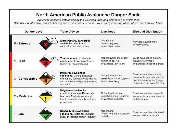
<p><span><span><span><span><span><span>Today with wind and periods of heavy snow the danger will be rising to CONSIDERABLE on wind loaded slopes. The danger on non-wind loaded slopes will rise to MODERATE.</span></span></span></span></span></span></p>
<p><span><span><span><span><span><span>In areas closer to Big Sky, snow has already started, and strong south winds will be forming shallow </span></span></span></span></span></span><span><span><span><strong><span><span>wind slabs</span></span></strong></span></span></span><span><span><span><span><span><span>. In areas further north, not much snow may fall until after winds start dying down and there will be minimal wind slab formation.</span></span></span></span></span></span></p>
<p><span><span><span><span><span><span>Today the avalanche danger is MODERATE. Look for and avoid fresh wind slabs and drifts.</span></span></span></span></span></span></p>
<p> </p>
Avalanche awareness focused on springtime avalanche conditions: TODAY, March 13 at the Bozeman REI from 6-7:30 p.m.
Toured into Texas Meadows this morning. No avalanche activity seen, no cracking or collapsing. Northern aspects and higher elevations holding better snow, without a wind or sun crust.