Good Morning. This is Alex Marienthal with the Gallatin National Forest Avalanche Advisory issued on Monday, December 18th at 6:45 a.m. Today’s advisory is sponsored by Yellowstone Club Community Foundation and Montana Ale Works. This advisory does not apply to operating ski areas.
Since yesterday the mountains near Cooke City got 2” of new snow, near West Yellowstone got 1”, and elsewhere got maybe a trace. Temperatures this morning are high 20s F near Bozeman and Big Sky and single digits to teens F near West Yellowstone and Cooke City. Wind is west-southwest at 25-40 mph near Bozeman and Big Sky, and 10-20 mph in the southern mountains. Today, temperatures will be 20s to low 30s F with west-southwest wind at 30-45 mph. Snow today will total 1-2” in most areas with 4-6” near Cooke City by morning.
In the mountains near Bozeman and Big Sky, strong wind yesterday morning drifted new snow into slabs 2-3 feet thick. Skiers in the Bridger Range and Hyalite easily triggered these wind slabs near ridgelines, on steep rollovers, and along the edges of cliffs (photo). These slabs are possible to trigger today, and large enough to carry or bury a person. Strong wind today will continue to grow wind slabs. Wind was from the northwest yesterday and changed to southwest overnight, so fresh slabs may be found in different locations than yesterday.
On non-wind loaded slopes, dry loose avalanches and storm slabs are possible to trigger and could run far and wide where the underlying snow is weak (video). These avalanches will likely be small, but could knock a person over or carry them into undesirable terrain.
Be extra cautious of wind loaded terrain today, and assess the consequences of being caught in even a small slide, such as being dragged through trees or over cliffs. Fresh wind slabs and recent snow make avalanches possible, and the avalanche danger today is MODERATE.
Near Cooke City and West Yellowstone 3-5” of low density snow fell over the weekend, and a couple inches are expected today. Strong wind will drift this snow into slabs 1-2 feet thick near ridgelines. Be cautious of these drifts, and completely avoid them where the consequences of a small slide could be a nasty ride through trees or over cliffs.
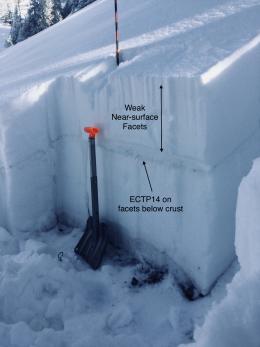
On some slopes, weak facets that formed during recent high pressure are now buried by the new snow (photo). Doug was in Cooke City yesterday and found this sugary weak layer below the new snow on all aspects (photo, video). This layer is not a major problem at the moment, but will produce avalanches when loaded with more snow or wind slabs.
Today, fresh wind slabs are possible and the avalanche danger is MODERATE on wind loaded slopes. On non-wind loaded slopes, avalanches are not likely until more snow falls and the avalanche danger today is LOW.
If you get out and have any avalanche or snowpack observations to share, drop a line via our website, email (mtavalanche@gmail.com), phone (406-587-6984), or Instagram (#gnfacobs).
Upcoming Avalanche Education and Events
BOZEMAN
Dec. 21, Avalanche Awareness, 6-7:30 P.m. at Play It Again Sports, Bozeman
Jan. 12 and 13, Companion Rescue Clinic, Info and Register
Jan. 17, 18 and 20 or 21, Introduction to Avalanches w/ Field Day, Info and Register Here
Jan. 24, 25 and 27, Advanced Avalanche Workshop w. Field Day, Info and Register Here
Feb. 9 and 10, Companion Rescue Clinic, Info and Register
WEST YELLOWSTONE
Today and tomorrow, Snowmobiler Introduction to Avalanches with Field Course, Info and Register Here
Jan. 6, Avalanche Awareness, 7-8 p.m. at West Yellowstone Holiday Inn Conference Center
COOKE CITY
22 and 23 December, Weekly Current Conditions and Avalanche Rescue, 6:30-7:30 p.m. Friday @ the Super 8, and anytime between 10-2 on Saturday @ Lulu Pass road
A daily checklist is a great way to help prevent common mistakes or overlooking important data when travelling in the backcountry. This article from Backcountry Magazine discusses how to use and create your own backcountry checklist.


