This is Dave Zinn with the avalanche forecast for Tuesday, February 4th, at 7:00 a.m. sponsored by Uphill Pursuits and the Yellowstone Club Community Foundation. This forecast does not apply to operating ski areas.
This morning, temperatures are in the 20s F, except for the low elevations in the Bridger Range, stubbornly sitting in the single digits above and below 0 F. Winds are 15-45 mph from the west through the south, with lighter winds in the Bridger Range.
In the last 24 hours, Cooke City received an additional 6-8” of snow, with 2-3” falling everywhere else.
Mountain snow totals since Friday:
- Cooke City - 30” of snow (3.0” snow water equivalent - SWE)
- West Yellowstone and Island Park - 16-21” of snow (2.0-2.4” SWE)
- Bridger, Madison, and Gallatin Ranges - 12-20” of snow (1.0-1.6” SWE)
Today, mountain temperatures will hover above and below the freezing mark, with cooler temperatures persisting in the Bridger Range. Winds will be 15-25 mph from the southwest. Across the forecast area, 2-4” of snow will fall by tomorrow morning, with a trace to 1” in the Bridger Range.
Since Friday, the mountains near Cooke City, West Yellowstone, and Island Park have received 16-30” of snow, equivalent to 2-3” of snow water equivalent, with Cooke City coming out on top. Snow fell on weak surfaces and strong winds are drifting new snow into cohesive slabs, making human-triggered avalanches likely on many slopes.
Persistent slab avalanches breaking 1-3 feet deep on buried weak layers of facets and surface hoar formed during last week’s high pressure are likely. These will break widely and may be triggered remotely from terrain near steep slopes. Avalanches failing on older weak layers buried near the base of the snowpack are possible. The likelihood of avalanches is amplified on wind-loaded slopes where the weight of drifted snow adds stress to weak layers.
Take the relatively short list on the Avalanche Activity Log with a grain of salt, given limited visibility:
- On Monday, Mark triggered a wind-loaded slope in the Centennial Mountains from a flat ridge top that broke 200 feet wide (video)
- A rider in the Lionhead area performed a re-entry, triggering a very small avalanche (video)
- We received reports of a few small wind slab avalanches over the weekend near Cooke City (avalanche log).
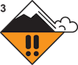
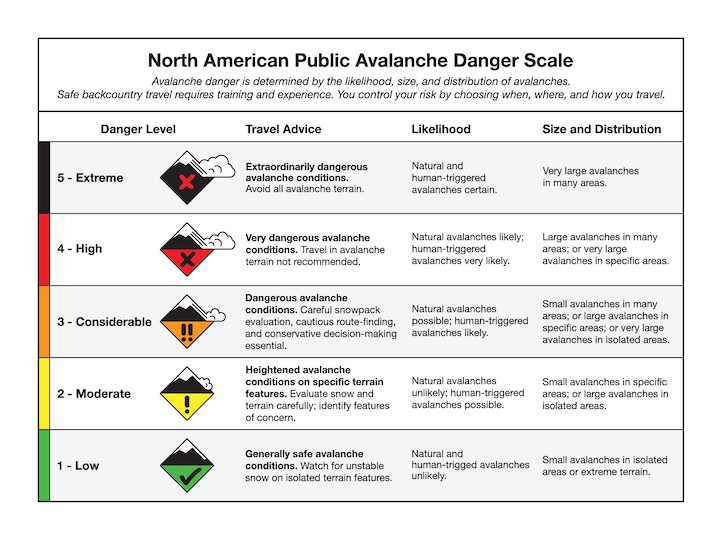
Avoid wind-loaded slopes and limit travel on any slope steeper than 30 degrees. This requires cautious route-finding and conservative decision-making. The avalanche danger is CONSIDERABLE.
The Madison and Gallatin Ranges received 12-20” of snow equal to 1.2-1.6” of SWE since Friday. The Big Sky area received the top end of this range.
Twenty to 40 mph winds are transporting recent snow into cohesive slabs and making human-triggered avalanches likely. Yesterday, wind-loaded slopes cracked under our skis on switchbacks and in stability assessments in Beehive Basin (video), and on Sunday, Mark and Alex observed cracks shooting 10-50 feet from their sleds in the Taylor Fork. Weak layers formed at the surface during last week’s high pressure are the primary culprit (observation, video).
Avoid wind-loaded slopes where human-triggered persistent slab and wind slab avalanches are likely. Dig down a few feet to look for weak layers and test for instability before considering travel on non-wind-loaded terrain steeper than 30 degrees. Shooting cracks, collapsing and recent avalanche activity supersede any indicator of stability.
The avalanche danger level is CONSIDERABLE on wind-loaded slopes and MODERATE on other slopes in the Madison and Gallatin Ranges.

The Bridger Range has received less snow than the rest of the forecast area, with 11” equal to 1.0” of SWE since Friday and less wind. Avalanches are possible within recently drifted snow. With light winds, areas of concern for wind slab avalanches are upper-elevation terrain near ridgelines, on more prominent alpine faces and below cornices.
While weak layers formed under last week’s clear skies exist on some slopes, windy and warmer conditions interrupted widespread weak layer formation in the Bridger Range. Evaluate slopes for shooting cracks, a stiffening of the snow surface, and potential wind-loading before considering steep terrain. Dig below the recent snow to evaluate for instability at the interface of the older snow and snow that fell since Friday.
Human-triggered avalanches are possible, and the avalanche danger is MODERATE.
KING AND QUEEN OF THE RIDGE RESULTS
On Saturday We closed out King and Queen of the Ridge with nearly $30,000 raised! We will post final numbers here after we confirm totals. Thank you to all who participated and raised funds for The Friends of the GNFAC.
Thank you to all who participated and raised funds for The Friends of the GNFAC, and a special shoutout to our top fundraising individuals and teams, many of them show up to raise thousands of dollars year after year! Dash Rodman ($4470), Matt Sebren ($3915), Ron June ($3220), Matt Pellmann ($1887), and Doug Child ($1110). Teams: Cooke City Exxon ($13056), Science Saves Lives ($4659), The Mountain Project ($3906), MAP Brewing ($1695), and BSF Skimo ($965).
Thank you to the Bridger Bowl Events team for all their work, Weston Boards, Bozeman Hot Springs and Blue Ice for donating prizes!
The King and Queen were Drake Fricke with 29 hikes and Jennifer Pierce with 24 hikes. Full Event Results.
Upcoming Avalanche Education and Events
Our education calendar is full of awareness lectures and field courses. Check it out: Events and Education Calendar
February 6, 6-8 p.m. & February 8, 10 a.m - 2 p.m. Companion Rescue Clinic. Evening lecture at REI in Bozeman. Field session at History Rock. Details and signup here.
February 20, 4-7 p.m. Beacon BBQ at Uphill Pursuits in Bozeman. Come try out different brands of avalanche transceivers (or practice with your own!) with coaching from Friends of GNFAC instructors and free hotdogs.
Every weekend in Cooke City: Friday at The Antlers at 7 p.m., Free Avalanche Awareness and Current Conditions talk, and Saturday from 10 a.m.-2 p.m. at Round Lake Warming Hut, Free Rescue Practice.
Thank you for sharing observations. Please let us know about avalanches, weather or signs of instability via the form on our website, or you can email us at mtavalanche@gmail.com, or call the office phone at 406-587-6984.