Good morning. This is Dave Zinn with the Gallatin National Forest Avalanche Forecast on Tuesday, February 14th at 7:00 a.m. This information is brought to you by our Valentines. Thanks for putting up with us! This forecast does not apply to operating ski areas.
Last night, the mountains across the advisory area received 4-7” of new snow, favoring the mountains near Bozeman and Big Sky. Temperatures are in the single digits to teens F with 5-15 mph winds from the southwest to the northwest. Today, temperatures will reach the teens to 20s F, and the wind will increase from the north to northwest to 10-25 mph. The mountains will receive an additional 3-6” of snow, with Hyalite Canyon getting 10.”
New snow plus increasing wind throughout the day create dangerous avalanche conditions in the mountains near Bozeman and Big Sky. This morning 6-7” of new snow equal to 0.4-0.5” of snow water equivalent (SWE) blankets the mountains. An additional 3-6” will fall today, with 10” in the Northern Gallatin Range, and winds will increase. As we discussed from Beehive Basin yesterday, as the snow falls and the wind blows, the danger increases (video).
Slabs of new and wind-drifted snow will be sensitive to human triggers, and the likelihood and potential size of avalanches will increase throughout the day with continuing snowfall. As the wind increases, drifts will grow thicker even as snowfall tapers off. Signs of instability within the new and wind-drifted snow, such as avalanches and shooting cracks, will be evident. Without digging and testing, signs of instability related to buried weak layers in the upper three feet of the snowpack will be less forthcoming but could result in avalanches breaking deeper and wider.
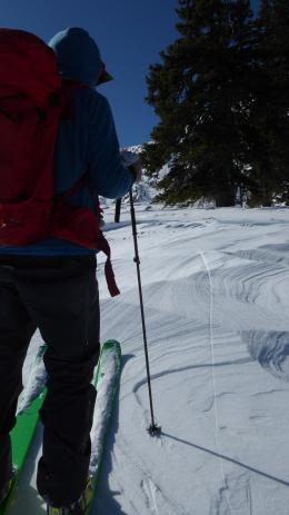
Conservative route-finding is the key to traveling safely during a storm. Visibility is restricted so you may not be able to see the obvious signs of instability around you. Ride and ski low-angle powder today, have fun, and stay safe.
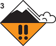
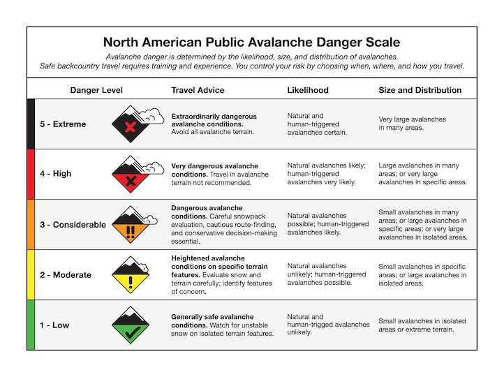
The avalanche danger is rated CONSIDERABLE.
The Southern Gallatin and Southern Madison Ranges and the mountains around West Yellowstone and Cooke City received 4-6” of snow last night, with an additional 2-5” expected during the day. New snow and increasing winds create dangerous conditions on wind-loaded slopes where avalanches are likely.
Relatively small slides breaking under the new and wind-drifted snow are concerning when terrain traps like trees, gullies and rocks are present (Island Park video). The size and destructive force of avalanches will increase throughout the day as snow continues to fall and drift. Larger avalanches breaking on deeper weak layers will be possible, especially on wind-loaded slopes where the depth of the new snow is enhanced.
Keep it simple today, as snow falls and the wind blows, the danger increases (relevant Beehive Basin video). On slopes with buried weak layers, avalanches could be larger, and slopes will stabilize more slowly. Avoid travel on or below steep wind-loaded terrain. Dig and test for instability in the upper three feet of the snowpack before considering travel in non-wind-loaded avalanche terrain.
The avalanche danger is rated CONSIDERABLE on wind-loaded terrain and MODERATE elsewhere.
Please share avalanche, snowpack or weather observations via our website, email (mtavalanche@gmail.com), phone (406-587-6984), or Instagram (#gnfacobs).

With 6” of fresh snow, slabs of new and wind-drifted snow will be sensitive to human triggers, and the potential size of these avalanches will increase throughout the day as snow continues to fall. As the wind increases, drifts will grow thicker even as snowfall tapers off (Island Park video). Buried weak layers in the upper three feet of the snowpack could result in avalanches breaking deeper and wider. Conservative route-finding and decision-making is the key to traveling safely during a storm. Ride and ski low-angle powder today, have fun, and stay safe.
Upcoming Avalanche Education and Events
Our education calendar is full of awareness lectures and field courses. Check it out: Events and Education Calendar.
February 16, FREE Avalanche Awareness night for women at REI Bozeman. Time TBD.
February 19, 10 a.m.-2p.m. Companion Rescue Clinic Field Day in the Bozeman area. Required Online Classroom Session at 6 p.m. on Feb 18. Information and course registration are HERE.
March 3-5, Bozeman Splitfest. More info and register here.
Every Saturday, 10 a.m. - 2:00 p.m. Avalanche Rescue Training, drop in for any amount of time. Round Lake Warming Hut, Cooke City. Free.
Loss in the Outdoors, is a support group for those who have been affected by grief and loss related to outdoor pursuits. Check out the link for more information.
Bruce Jamieson’s videos on Snow Science explain heady topics to the layman. Understanding the avalanche dragon helps keep us alive.