Good morning. This is Ian Hoyer with the Gallatin National Forest Avalanche Forecast on Friday, February 10th at 7:00 a.m. This information is sponsored by Blitz Motorsports and Yamaha and Avalanche Alliance. This forecast does not apply to operating ski areas.
There is no new snow to report. Winds are 15-20 mph out of the south and west, with gusts of 25-35 mph. Mountain temperatures are in the single digits to 20s F. An inversion in the north has mountain temperatures much warmer than valley temps, while it’s just consistently cold in the south. Temperatures today will rise into the 20s and 30s F under mostly sunny skies. Winds will remain moderate out of the south and west. The next chance of snow is early next week.

You could trigger an avalanche today beneath a wind drift or deeper on a variety of weak layers buried throughout the snowpack. Yesterday, riders in Tepee Creek triggered an avalanche that broke a foot deep and ~150 ft wide, a clear reminder that the potential to trigger a slide remains (observation).
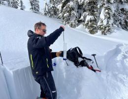
Strong winds drifted the snow that fell earlier this week. The wind drifts themselves have now had a little time to bond and triggering an avalanche without additional weak layers is becoming less likely. Unfortunately, on many slopes new persistent weak layers were buried just beneath these drifts and these layers will stabilize much more slowly. There are also other weak layers throughout the snowpack that continue to break in stability tests (Hyalite video). Persistent weak layers have been more stressed and are more likely to avalanche on windloaded slopes.
Avoid wind drifts to avoid the likeliest places to trigger avalanches (Buck Ridge video). The deeper the drift, the more likely you are to trigger a slide. Watch for cracks shooting out in front of you as a clear sign you’ve found an unstable drift. Don’t take any of this to mean non-windloaded slopes are completely safe - the potential to trigger a slide still needs to be evaluated carefully. Dig down and test the weak layers in the upper 3-4 ft of the snowpack before riding any steep slopes.
There may be some small wet loose slides on the warmest, sunniest slopes this afternoon but they’ll just be a few inches deep and won’t be much of a hazard.
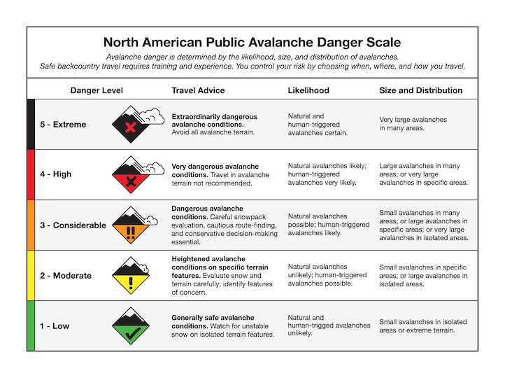
The avalanche danger is rated MODERATE across the advisory area.
Please share avalanche, snowpack or weather observations via our website, email (mtavalanche@gmail.com), phone (406-587-6984), or Instagram (#gnfacobs).

In Island Park, you could trigger an avalanche today beneath a wind drift or deeper on a variety of weak layers buried throughout the snowpack. Avoid wind drifts to avoid the likeliest places to trigger avalanches. The deeper the drift, the more likely you are to trigger a slide Watch for cracks shooting out in front of you as a clear sign you’ve found an unstable drift. Dig down and test the weak layers in the upper 3-4 ft of the snowpack before riding any steep slopes.
Upcoming Avalanche Education and Events
Our education calendar is full of awareness lectures and field courses. Check it out: Events and Education Calendar.
February 16, FREE Avalanche Awareness night for women at REI Bozeman. Time TBD.
February 19, 10 a.m.-2p.m. Companion Rescue Clinic Field Day in the Bozeman area. Required Online Classroom Session at 6 p.m. on Feb 18. Information and course registration are HERE.
March 3-5, Bozeman Splitfest. More info and register here.
Every Saturday, 10 a.m. - 2:00 p.m. Avalanche Rescue Training, drop in for any amount of time. Round Lake Warming Hut, Cooke City. Free.
Loss in the Outdoors, is a support group for those who have been affected by grief and loss related to outdoor pursuits. Check out the link for more information
Bruce Jamieson’s videos on Snow Science explain heady topics to the layman. Understanding the avalanche dragon helps keep us alive.