Good morning. This is Dave Zinn with the Gallatin National Forest Avalanche Forecast on Tuesday, February 7th at 7:15 a.m. This information is sponsored by Klim, FUGOWEE Snowmobile Club and the Upper Yellowstone Snowmobile Club. This forecast does not apply to operating ski areas.
This morning, temperatures are in the teens to 20s F with 20-30 mph winds from the west in the Bridger and Northern Gallatin Ranges, and 10-15 mph from the west to southwest elsewhere. In the last 24 hours, Cooke City received 3” of new snow, with 1” in Taylor Fork. Today, temperatures will be in the 20s F with 10-15 mph winds from the west to southwest and 15-25 mph winds near Bozeman. The mountains near West Yellowstone will get 2” of snow by morning, with an inch everywhere else.
In the Bridger and Northern Madison Ranges, four to 6” of snow since Sunday night is being blown into drifts by 20 to 30 mph winds. Human-triggered avalanches are likely on freshly wind-loaded slopes. High-elevation terrain near ridgelines, gullies loaded by spindrift and other slopes with fresh drifts are all suspect. Avoid slopes with of recent or ongoing wind loading or signs of instability, such as recent avalanches, shooting cracks, and collapsing.
Persistent weak layers buried in the upper few feet of the snowpack and near the ground make deeper avalanches possible on both wind-loaded and non-wind-loaded terrain. Ian described these weak layers in his video from the Bridger Range, as did Alex in his video from the Northern Gallatin Range last week.
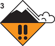
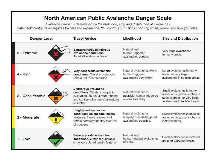
Avoid wind-loaded slopes where the danger is CONSIDERABLE. Dig and test for weak layers in the upper 3 feet of the snowpack before considering travel in non-wind-load avalanche terrain where the danger is MODERATE.

Since Sunday night, four to 7” of snow fell in the mountains near Big Sky, West Yellowstone and Cooke City. Persistent weak layers of feathery surface hoar and sugary facets exist in the upper three feet of the snowpack on most slopes across the area. Slopes with more recent snow or drifts of wind-loaded snow are the most dangerous today.
Recently, Alex uncovered the concerning weak layers in the top three feet of the snowpack in Beehive Basin near Big Sky (video) and north of Cooke City (Cooke video). Go back a full week with our videos and we describe similar conditions in all regions of the advisory area. Recent avalanches are the clearest indicators of potential instability. Yesterday, riders triggered a 30’ wide avalanche on Sheep Mountain near Cooke City that broke up to two feet deep (photo and details). On Thursday and Friday of last week, skiers triggered two avalanches in the backcountry outside Big Sky Ski Resort, with one skier caught and carried (details 1, details 2). A rider captured some spooky point-of-view footage when he was carried in a small avalanche near Buck Ridge at night (details and video), a skier was buried to their waist on Fisher Mountain (details) and a rider triggered a small slide on Mount Abundance near Cooke City (details).
If you are considering steeper terrain, dig down and test for instability related to weak layers in the upper three feet of the snowpack. The avalanche danger is rated MODERATE.
Please share avalanche, snowpack or weather observations via our website, email (mtavalanche@gmail.com), phone (406-587-6984), or Instagram (#gnfacobs).

The mountains in Island Park received up to 7” of new snow since Sunday night. Avalanches are possible in thicker drifts near ridgelines and on slopes with buried weak layers in the top three feet of the snowpack. Avoid slopes where pillows of drifted snow show signs of instability, such as shooting cracks and dig to perform an extended column test to investigate potential instability related to weak layers before riding steep slopes.
Yesterday, Doug and I rode in the Centennials and found weak layers in the upper three feet of the snowpack. They were not propagating failure in our stability tests. This is a good sign, but we are not ready to trust them. Today, we will continue hunting for instability in Island Park (video).
King and Queen of the Ridge Results
Thank you and great work to everyone who participated in this year’s King and Queen of the Ridge event. This year we set a fund-raising record of $31,626! We greatly appreciate the support from everyone who hiked, donated, and raised money for The Friends of GNFAC. The King of the Ridge for the second year in a row is Casey Bloomer, with a record 34 hikes, and Queen is Rachel Topf, with 23 hikes! Full Results Here.
This year's top 3 fundraisers were Dash Rodman (1) and Matt Sebren (2) of team Cooke City Exxon and Janis Putelis (3) of team Highline Partners/ New Age Artisans. The top three fundraising teams were Cooke City Exxon, Highline Partners/ New Age Artisans and team Science Saves Lives.
Upcoming Avalanche Education and Events
Our education calendar is full of awareness lectures and field courses. Check it out: Events and Education Calendar.
February 9, FREE Avalanche Awareness at REI Bozeman. More details to come.
February 11, 10 a.m.-2p.m. Companion Rescue Clinic Field Day in the Bozeman area. Required Online Classroom Session at 6 p.m. on Feb 10. Information and course registration are HERE.
February 16, FREE Avalanche Awareness night for women at REI Bozeman. Time TBD.
March 3-5, Bozeman Splitfest. More info and register here.
Every Saturday, 10 a.m. - 2:00 p.m. Avalanche Rescue Training, drop in for any amount of time. Round Lake Warming Hut, Cooke City. Free.
Loss in the Outdoors, is a support group for those who have been affected by grief and loss related to outdoor pursuits. Check out the link for more information.

Bruce Jamieson’s videos on Snow Science explain heady topics to the layman. Understanding the avalanche dragon helps keep us alive.