Good morning. This is Alex Marienthal with the Gallatin National Forest Avalanche Forecast on Sunday, December 11th at 7:15 a.m. This information is sponsored by Stronghold Fabrication, Community Food Co-op and Upper Yellowstone Snowmobile Club. This forecast does not apply to operating ski areas.
Please consider donating to the Friends of GNFAC Annual Fundraiser.
Since yesterday morning 1-2” of snow fell near Cooke City, the southern Madison Range and West Yellowstone with none elsewhere. Yesterday the wind was southerly at 20-30 mph with gusts of 50-65 mph. This morning southerly wind has decreased to 10-20 mph with gusts to 40 mph. Temperatures are teens to high 20s F this morning, and will reach high 20s to low 30s F today. Snowfall is expected in some areas through the day with 4-8” possible near West Yellowstone and the southern Madison Range, 2” near Cooke City and maybe 1” elsewhere.
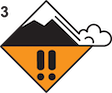
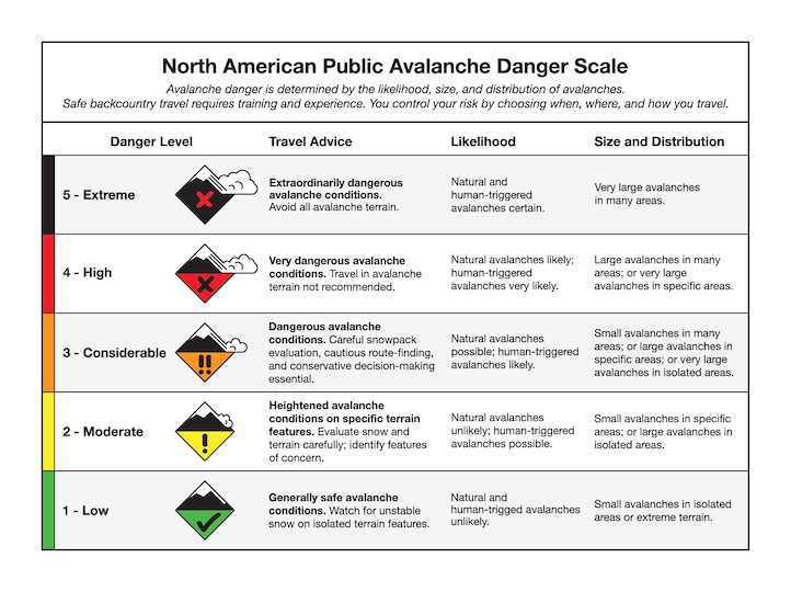
More new snow and southerly wind today will create dangerous avalanche conditions. Weak layers buried 2-3 feet deep will be under additional stress from the weight of new snow, especially where snow is drifted into thicker slabs (Lionhead avalanche video). Human-triggered avalanches are likely, and may be triggered from lower angle terrain below steep slopes. Avoid steep slopes, especially slopes that are wind-loaded, and give them a wide berth if crossing beneath them. Avalanche danger is CONSIDERABLE.

Near Cooke City it is possible to trigger a large avalanche, breaking more than 3 feet deep on buried weak layers. These mountains will not receive much snow today and southerly wind has decreased. This will decrease the likelihood of triggering a large avalanche, but the consequences remain large. On Friday, my partner and I triggered an avalanche that broke 3-6 ft deep and 500 feet above us while we were crossing below a steep slope near Lulu Pass (video, photo). My partner was carried, but not buried and was uninjured. This was only the latest in a string of large natural and human triggered avalanches over the last week (Daisy Pass video, Henderson photo and details). If you plan to travel on or below steep slopes, carefully assess the snowpack for buried weak layers and wind-loading, and consider the consequences of triggering a large avalanche. The avalanche danger is MODERATE.
Yesterday, moderate to strong south-southwest wind blew 2-4” of recent snow into thick drifts that can avalanche under the weight of a person. Snowmobilers on Buck Ridge reported a cornice triggered avalanche (photos and details), skiers in the Bridger Range triggered fresh wind slabs (photos and details), and skiers in Hyalite saw a powder cloud from a cornice fall or wind slab in the Main Fork (photo) and a recent wind slab on Mt. Blackmore (photo). Doug was climbing in Hyalite on Friday and found a 10” deep wind slab sitting over a thin weak layer (Hyalite gullies video). A setup like this will make drifts possible to trigger. Before crossing or riding steep slopes, carefully assess the snowpack for wind slabs resting over weak layers and consider the consequences of even a small slide. The avalanche danger is MODERATE.
If you get out, please share avalanche, snowpack or weather observations via our website, email (mtavalanche@gmail.com), phone (406-587-6984), or Instagram (#gnfacobs).

Heavy snowfall and strong winds make for dangerous avalanche conditions today. Two days ago, Dave and Ian found up to 18” of new snow while riding in Yale Creek and drifts up to 4 ft deep (field video). They also found weak layers similar to what we’ve seen in Lionhead (field observations). Avoid steep slopes today and give them a wide berth if you’re crossing beneath them. Stick to low angle slopes and enjoy the fresh snow. Human triggered avalanches are likely.
Upcoming Avalanche Education and Events
Our education calendar is full of awareness lectures and field courses. Check it out: Events and Education Calendar.
Monday, December 12, 5-8 p.m. @MAP Brewing, Movie Night.
Tuesday, December 13, 6 p.m., Avalanche Awareness + Beacons at Story Mill Park. Free.
Watch our playlist of YouTube videos to get caught up on our avalanche concerns this season.